Lakeland, Georgia
| Lakeland, Georgia | |
|---|---|
| City | |

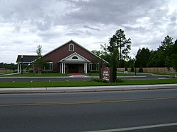
Lakeland City Hall and Lakeland Police Department
|
|
 Location in Lanier County and the state of Georgia |
|
| Coordinates: 31°2′21″N 83°4′13″W / 31.03917°N 83.07028°WCoordinates: 31°2′21″N 83°4′13″W / 31.03917°N 83.07028°W | |
| Country | United States |
| State | Georgia |
| County | Lanier |
| Area | |
| • Total | 3.1 sq mi (8.1 km2) |
| • Land | 3.1 sq mi (8 km2) |
| • Water | 0 sq mi (0.1 km2) |
| Elevation | 200 ft (61 m) |
| Population (2000) | |
| • Total | 2,730 |
| • Density | 880.6/sq mi (337/km2) |
| Time zone | Eastern (EST) (UTC-5) |
| • Summer (DST) | EDT (UTC-4) |
| ZIP code | 31635 |
| Area code(s) | 229 |
| FIPS code | 13-44592 |
| GNIS feature ID | 0356347 |
Lakeland is a city in Lanier County, Georgia, United States. The city is the county seat of Lanier County. It is part of the Valdosta, Georgia Metropolitan Statistical Area. The population was 2,730 at the 2000 census.
Originally called Alapaha and then Milltown or Mill Town, Lakeland received its current name in 1925 in honor of its proximity to Grand Bay Lake, Lake Erma, and Banks Lake. For many years, Lakeland owned and operated its own railroad.
Numerous festivals are held in the county throughout each year. One, is the Flatlanders Frolic Arts and Crafts Show. This event features bluegrass music, a road race and various other Labor Day weekend events. Also held in Lanier County is the Living Murals Celebration held in the Spring and most recently the Georgia Deep Woods Deerfest, a festival featuring wild game suppers and firearms giveaways.
By the early 1840s, a community known as Alapaha had come into existence along the road from Waresboro, Georgia to Troupville, Georgia. By the late 1850s, Alapaha had become known as Milltown. Lakeland, originally known as Milltown. Milltown was incorporated in 1901. In 1919, Milltown was designated seat of the newly formed Lanier County. In 1928, the city was incorporated and renamed to its present form of Lakeland.
Lakeland is located at 31°2′21″N 83°4′13″W / 31.03917°N 83.07028°W (31.039214, -83.070397).
According to the United States Census Bureau, the city has a total area of 3.1 square miles (8.0 km2), of which, 3.1 square miles (8.0 km2) of it is land and 0.04 square miles (0.10 km2) of it (1.28%) is water.
...
Wikipedia
