Alamo, Indiana
| Alamo, Indiana | |
|---|---|
| Town | |
 |
|
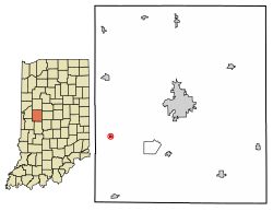
 Location of Alamo in Montgomery County, Indiana. |
|
| Coordinates: 39°59′1″N 87°3′18″W / 39.98361°N 87.05500°WCoordinates: 39°59′1″N 87°3′18″W / 39.98361°N 87.05500°W | |
| Country | United States |
| State | Indiana |
| County | Montgomery |
| Township | Ripley |
| Area | |
| • Total | 0.07 sq mi (0.17 km2) |
| • Land | 0.07 sq mi (0.17 km2) |
| • Water | 0.00 sq mi (0.00 km2) |
| Elevation | 814 ft (248 m) |
| Population (2010) | |
| • Total | 66 |
| • Estimate (2016) | 65 |
| • Density | 970.15/sq mi (372.95/km2) |
| Time zone | Eastern (EST) (UTC−5) |
| • Summer (DST) | EST (UTC−5) |
| ZIP code | 47916 |
| Area code | 765 |
| FIPS code | 18-00784 |
| GNIS ID | 430039 |
Alamo is a town in Ripley Township, Montgomery County, in the U.S. state of Indiana. The population was 66 at the 2010 census.
Alamo is located at 39°59′1″N 87°3′18″W / 39.98361°N 87.05500°W (39.983709, -87.055078).
According to the 2010 census, Alamo has a total area of 0.07 square miles (0.18 km2), all land.
Alamo was laid out and platted in 1837. It became a small trading center for nearby farms. In 1859 a road connected Alamo to Crawfordsville and the Yountsville Covered Bridge was built. The town was named for the Alamo Mission in San Antonio, Texas.
The post office at Alamo has been in operation since 1844.
As of the 2010 Census, there were 66 people, 26 households, and 17 families residing in the town. The population density was 942.9 inhabitants per square mile (364.1/km2). There were 39 housing units at an average density of 557.1 per square mile (215.1/km2). The racial makeup of the town was 89.4% White, 3.0% Native American, 6.1% from other races, and 1.5% from two or more races. Hispanic or Latino of any race were 6.1% of the population.
...
Wikipedia

