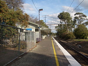
Alamein railway station
|
Alamein
|
|||||||||||
|---|---|---|---|---|---|---|---|---|---|---|---|

Southbound view in May 2008
|
|||||||||||
| Location | Ashburn Grove, Ashburton | ||||||||||
| Coordinates | 37°52′06″S 145°04′47″E / 37.8683°S 145.0797°ECoordinates: 37°52′06″S 145°04′47″E / 37.8683°S 145.0797°E | ||||||||||
| Owned by | VicTrack | ||||||||||
| Operated by | Metro | ||||||||||
| Line(s) | Alamein | ||||||||||
| Distance | 16.12 kilometres from Southern Cross | ||||||||||
| Platforms | 1 | ||||||||||
| Tracks | 1 | ||||||||||
| Construction | |||||||||||
| Structure type | Ground | ||||||||||
| Disabled access | Yes | ||||||||||
| Other information | |||||||||||
| Status | Unstaffed station | ||||||||||
| Station code | ALM | ||||||||||
| Fare zone | Myki zone 1 | ||||||||||
| Website | Public Transport Victoria | ||||||||||
| History | |||||||||||
| Opened | 28 June 1948 | ||||||||||
| Electrified | Yes | ||||||||||
| Services | |||||||||||
|
|||||||||||
Alamein railway station is the terminus of the Alamein line in Victoria, Australia. It serves the eastern Melbourne suburb of Ashburton opening on 28 June 1948.
In 2011/12 it was the 8th least used station on Melbourne's metropolitan network, with 153,000 passenger movements.
Alamein was the last station to be built on what is now the line of the same name. It opened in 1948 on the reservation of the former Outer Circle line, the section on which Alamein is now located having been closed to all traffic in 1895.
The station served a new Housing Commission estate that had been constructed for people who were displaced after World War II. The station still bears the name of the estate, which in turn had been named after the World War II battlefield in North Africa.
The Outer Circle Trail for cyclists and walkers continues along the Outer Circle alignment after Alamein as far as Gardiners Creek and the Malvern Valley Public Golf Course, and then connects with the Gardiners Creek Trail and a path to East Malvern.
Alamein has one platform. It is serviced by Metro Trains' Alamein line services.
Platforms 1:
...
Wikipedia
