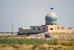
Al Kut
|
Kut الكوت |
|
|---|---|

Mosque in Al Kut (2003)
|
|
| Coordinates: 32°30′20″N 45°49′29″E / 32.50556°N 45.82472°ECoordinates: 32°30′20″N 45°49′29″E / 32.50556°N 45.82472°E | |
| Country |
|
| Governorate | Wasit |
| Elevation | 23 m (75 ft) |
| Population | |
| • Total | 374,000 |
Al-Kūt (Arabic: الكوت; BGN: Al Kūt; also spelled Kut al-Imara or Kut El Amara; Kurdish: Kût; Turkish: Kut'ül Ammare or Kut) is a city in eastern Iraq, on the left bank of the Tigris River, about 160 kilometres (99 miles) south east of Baghdad. As of 2003[update] the estimated population is about 374,000 people. It is the capital of the province long known as Al Kut, but since the 1960s renamed Wasit.
The old town of Kut is within a sharp "U" bend of the river, almost making it an island but for a narrow connection to the shore. For centuries Kut was a regional center of the carpet trade. The area around Kut is a fertile cereal grain growing region. The Baghdad Nuclear Research Facility, looted following the 2003 invasion of Iraq, is located near Kut.
The Kut Barrage was constructed in the city in the 1930s to provide irrigation water for the surrounding area. The barrage supports a road and includes a lock for boats passing up and down the Tigris. Its purpose is to maintain a sufficiently high water level in the Tigris to provide water for the Gharraf irrigation canal.
In 1952, 26,440 hectares (65,300 acres) were irrigated from water provided by the Gharraf Canal. Of this newly reclaimed land, 14,080 hectares (34,800 acres) was distributed to small farmers as part of a social land reform program. These farmers received 10 hectares (25 acres) per family and were required to live on the land they farmed. In 2005, repairs and maintenance works were carried out at the Kut Barrage and the Gharraf Head Regulator for a total cost of US$3 million.
...
Wikipedia

