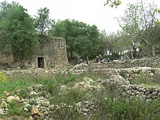
Al-Qabu
| al-Qabu | |
|---|---|

The mosque for Shaykh Ahmad al-Umari
|
|
| Arabic | القبو |
| Name meaning | "the vault, or cellar" |
| Also spelled | Qabu, Kabu |
| Subdistrict | Jerusalem |
| Coordinates | 31°43′40″N 35°07′10″E / 31.72778°N 35.11944°ECoordinates: 31°43′40″N 35°07′10″E / 31.72778°N 35.11944°E |
| Palestine grid | 161/126 |
| Population | 260 (1945) |
| Area | 3,806 dunams 3.8 km² |
| Date of depopulation | 22–23 October 1948 |
| Cause(s) of depopulation | Military assault by Yishuv forces |
| Current localities | Mevo Betar |
Al-Qabu (Arabic: القبو, "the vault, or cellar"), was a Palestinian Arab village in the Jerusalem Subdistrict. The name is an Arabic variation of the site's original Roman name, and the ruins of a church there are thought to date to the era of Byzantine or Crusader rule over Palestine.
Al-Qabu was depopulated on 22–23 October 1948, following the 1948 Arab-Israeli War. Following Israel's establishment, homes in the village were blown up by Israeli troops in May 1949 and in 1950, the Israeli locality of Mevo Betar was founded on the village lands.
Situated on a hilltop that sloped downward steeply on three sides, to the south lay a secondary road that linked al-Qabu to the highway between Bayt Jibrin and Jerusalem which lay at a distance of about 1.5 kilometers (0.93 mi).
During the period of Roman rule over Palestine, the place was known as Qobi or Qobia. The village had a spring, and was located at the tenth milestone on the road constructed between Bayt Jibrin and Jerusalem under emperor Hadrian. The Arabic name of the Palestinian village, al-Qabu, was a modification of the earlier Roman name.
A ruined church by the village was visited by a team from the Survey of Western Palestine in 1873, and they determined that it appeared to date to the period of the Crusades, while other researchers, such as Reverend Dom M. Gisler, OSB in 1939, have determined that it dates to the Byzantine era.
...
Wikipedia

