Aitana
| Aitana | |
|---|---|

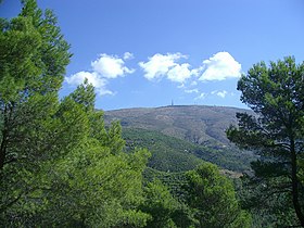
Aitana peak and the antenna of EVA
|
|
| Highest point | |
| Peak | Aitana |
| Elevation | 1,558 m (5,112 ft) |
| Coordinates | 38°39′39″N 0°16′29″W / 38.66083°N 0.27472°WCoordinates: 38°39′39″N 0°16′29″W / 38.66083°N 0.27472°W |
| Dimensions | |
| Length | 8 km (5.0 mi) E/W |
| Width | 3 km (1.9 mi) N/S |
| Area | 20 km² |
| Geography | |
| Location | Marina Baixa, Alcoià and Comtat, Valencian Community |
| State/Province | ES-VA |
| Parent range | Baetic System |
| Geology | |
| Type of rock | Limestone |
Aitana (Valencian: [ajˈtana], Spanish: [aiˈtana]) is a mountain massif that is part of Prebaetic System in the eastern end of the Iberian Peninsula. Administratively, the mountainous area is located in the Marina Baixa, Alcoià and Comtat comarcas in the northern part of Alicante province, Valencian Community, Spain. Its peak at 1,558 metres above sea level is the highest point of the province.
Aitana mountain range is spread over an area of 2,000 hectares, about ten miles from the Mediterranean coast. Apart from Aitana, the highest peak that gives the name to the mountain system, other notable peaks are Penya Alta (1,506 m), Penya Catxa (1,467 m), El Mulero (1,308 m) and Alt del Carrascar (1,208 m).
Aitana is also a common girls' name in the areas surrounding the mountain range. The summit has also been a mountain finish in la Vuelta a España a number of times. The Alto de Aitana is a 22.3 kilometer long grinder and has an average gradient of 6% and can also be compared with Mount Ventoux, though Ventoux is steeper.
...
Wikipedia

