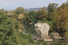
Aesepus Bridge
| Aesepus Bridge (Dove Bridge) |
|
|---|---|

Central pier (view from south)
|
|
| Coordinates | 40°16′36″N 27°36′12″E / 40.276667°N 27.603333°ECoordinates: 40°16′36″N 27°36′12″E / 40.276667°N 27.603333°E |
| Carries | Roman road to Kyzikos |
| Crosses | Aesepus (Gönen Çayı) |
| Locale | Ancient Mysia, now Gönen district, Balıkesir Province, Turkey |
| Characteristics | |
| Design | Arch bridge |
| Material | Stone |
| Total length | c. 158 m |
| Width | 5.60 m |
| Longest span | 12.20 m |
| Number of spans | 11 (incl. floodways) |
| History | |
| Construction end | 4th or 5th/6th century AD |
The Aesepus Bridge (Turkish: Güvercin Köprüsü, "Dove Bridge") was a late antique Roman bridge over the Aesepus river (today Gönen Çayı) in the ancient region of Mysia in modern-day Turkey. It is notable for its advanced hollow chamber system which has also been employed in other Roman bridges in the region, such as the Makestos Bridge. In a field examination carried out in the early 20th century, the four main vaults of the bridge were found in ruins, while nearly all piers and the seven minor arches had still remained intact. Today, the two remaining pier stubs in the riverbed are still extant, while the condition of the rest of the structure is difficult to determine.
The Aesepus Bridge is located in northwestern Turkey, 8 km north of Sariköy as the crow flies, approximately 5.6 km upstream of where the Gönen Çayı flows into the Sea of Marmara, slightly above the point where the narrow river valley opens into the wide estuary plain and a modern bridge carries the highway 200 across the Gönen Çayı. The Aesepus Bridge was part of a Roman road, which in ancient times led across Mysia to the coastal town of Cyzicus, and which, having preserved some of its original Roman paving of 13–15 cm deep small round stones, was in the 19th century still the preferred route for travelling between close-by Bandırma (Panderma) and Boghashehr.
The earliest investigation on the Aesepus Bridge was published by the British archaeologist Hasluck in 1906. Based on structural similarities with other hollow chamber bridges in Mysia like the White Bridge and the Makestos Bridge, as well as Constantine's Bridge, he dates the bridge quartet to the early 4th century AD, in the era of Constantine the Great († 337 AD), when Byzantium was elevated to the capital of the eastern half of the empire.
...
Wikipedia

