2016 Pacific typhoon season
| 2016 Pacific typhoon season |
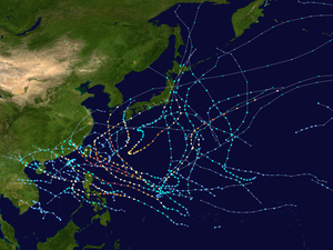
Season summary map
|
| Seasonal boundaries |
| First system formed |
May 25, 2016 |
| Last system dissipated |
December 28, 2016 |
| Strongest storm |
|
| Name |
Meranti |
| • Maximum winds |
220 km/h (140 mph)
(10-minute sustained) |
| • Lowest pressure |
890 hPa (mbar) |
| Seasonal statistics |
| Total depressions |
53 |
| Total storms |
26 |
| Typhoons |
13 |
| Super typhoons |
6 (unofficial)
|
| Total fatalities |
888 |
| Total damage |
$11.3 billion (2016 USD) |
| Related articles |
|
|
Pacific typhoon seasons
2014, 2015, 2016, 2017, 2018
|
| Tropical depression (JMA) |
| Tropical depression (SSHWS) |
|
|
| Duration |
May 25 – May 27 |
| Peak intensity |
45 km/h (30 mph) (1-min) 1000 hPa (mbar) |
| Tropical depression (JMA) |
|
|
| Duration |
June 25 – June 28 |
| Peak intensity |
55 km/h (35 mph) (10-min) 1002 hPa (mbar) |
| Typhoon (JMA) |
| Category 5 super typhoon (SSHWS) |
|
|
| Duration |
July 2 – July 10 |
| Peak intensity |
205 km/h (125 mph) (10-min) 900 hPa (mbar) |
| Tropical depression (JMA) |
| Tropical depression (SSHWS) |
|
|
| Duration |
July 16 – July 20 |
| Peak intensity |
45 km/h (30 mph) (1-min) 1006 hPa (mbar) |
| Tropical storm (JMA) |
| Tropical storm (SSHWS) |
|
|
| Duration |
July 22 – July 24 |
| Peak intensity |
75 km/h (45 mph) (10-min) 1000 hPa (mbar) |
| Severe tropical storm (JMA) |
| Tropical storm (SSHWS) |
|
|
| Duration |
July 25 – July 28 |
| Peak intensity |
100 km/h (65 mph) (10-min) 980 hPa (mbar) |
| Severe tropical storm (JMA) |
| Category 1 typhoon (SSHWS) |
|
|
| Duration |
July 29 – August 3 |
| Peak intensity |
110 km/h (70 mph) (10-min) 975 hPa (mbar) |
| Severe tropical storm (JMA) |
| Tropical storm (SSHWS) |
|
|
| Duration |
August 2 – August 9 |
| Peak intensity |
110 km/h (70 mph) (10-min) 975 hPa (mbar) |
| Tropical storm (JMA) |
| Tropical storm (SSHWS) |
|
|
| Duration |
August 7 – August 15 |
| Peak intensity |
85 km/h (50 mph) (10-min) 985 hPa (mbar) |
The 2016 Pacific typhoon season had the fifth-latest start for a Pacific typhoon season since reliable records began. It was a near-average season, with a total of 26 named storms, 13 typhoons and six super typhoons. The season ran throughout 2016, though typically most tropical cyclones develop between May and October. The season’s first named storm, Nepartak, developed on July 3, while the season’s last named storm, Nock-ten, dissipated on December 28.
The development of Nepartak made the second-latest time within a season for the first named storm to develop and ended a 199-day period (from December 17, 2015 – July 3, 2016) during which no named storm was active in the basin. Tropical Storm Mirinae reached peak intensity while making landfall over the Red River Delta, causing very severe damage in Northern Vietnam. By the end of August, three storms had hit the Japanese island of Hokkaidō, the most since 1951. In September, Typhoon Meranti reached peak intensity with a minimum pressure of 890 hPa, becoming one of the most intense tropical cyclones on record. Typhoon Chaba became the strongest typhoon to strike South Korea since 2012. Tropical Storm Aere and a tropical depression brought the worst flooding in Vietnam since 2011. The last storm of the season, Typhoon Nock-ten, became the strongest tropical cyclone ever recorded worldwide on Christmas Day (December 25) since at least 1960, in terms of 1-minute maximum sustained winds.
The scope of this article is limited to the Pacific Ocean to the north of the equator between 100°E and the 180th meridian. Within the northwestern Pacific Ocean, there are two separate agencies that assign names to tropical cyclones, which often results in a storm having two names. The Japan Meteorological Agency (JMA) will name a tropical cyclone should it be judged to have 10-minute sustained wind speeds of at least 65 km/h (40 mph) anywhere in the basin, whilst the Philippine Atmospheric, Geophysical and Astronomical Services Administration (PAGASA) assigns names to tropical cyclones which move into or form as tropical depressions in their area of responsibility, located between 115°E and 135°E and between 5°N and 25°N, regardless of whether or not the tropical cyclone has already been given a name by the JMA. Tropical depressions monitored by the United States' Joint Typhoon Warning Center (JTWC) are given a number with a "W" suffix.
...
Wikipedia


