2012–13 South Pacific cyclone season
| 2012–13 South Pacific cyclone season |
Season summary map
|
| Seasonal boundaries |
| First system formed |
November 6, 2012 |
| Last system dissipated |
May 1, 2013 |
| Strongest storm |
|
| Name |
Sandra |
| • Maximum winds |
185 km/h (115 mph)
(10-minute sustained) |
| • Lowest pressure |
930 hPa (mbar) |
| Seasonal statistics |
| Total disturbances |
22 |
| Total depressions |
11 |
| Tropical cyclones |
5 |
| Severe tropical cyclones |
4 |
| Total fatalities |
17 total |
| Total damage |
$315.8 million (2012 USD) |
| Related articles |
|
|
South Pacific tropical cyclone seasons
2010–11, 2011–12, 2012–13, 2013–14, 2014–15
|
| Tropical depression (Australian scale) |
|
|
| Duration |
November 18 – November 24 |
| Peak intensity |
45 km/h (30 mph) (10-min) 1001 hPa (mbar) |
| Tropical depression (Australian scale) |
| Subtropical storm (SSHWS) |
|
|
| Duration |
December 9 – December 17 |
| Peak intensity |
Winds not specified 997 hPa (mbar) |
| Category 4 severe tropical cyclone (Australian scale) |
| Category 4 tropical cyclone (SSHWS) |
|
|
| Duration |
December 9 – December 19 |
| Peak intensity |
185 km/h (115 mph) (10-min) 943 hPa (mbar) |
| Category 4 severe tropical cyclone (Australian scale) |
| Category 3 tropical cyclone (SSHWS) |
|
|
| Duration |
December 26 – January 4 |
| Peak intensity |
185 km/h (115 mph) (10-min) 940 hPa (mbar) |
| Tropical depression (Australian scale) |
|
|
| Duration |
January 9 – January 15 |
| Peak intensity |
45 km/h (30 mph) (10-min) 999 hPa (mbar) |
| Category 3 severe tropical cyclone (Australian scale) |
| Category 2 tropical cyclone (SSHWS) |
|
|
| Duration |
January 14 – January 27 |
| Peak intensity |
150 km/h (90 mph) (10-min) 965 hPa (mbar) |
| Tropical depression (Australian scale) |
|
|
| Duration |
January 26 – January 30 |
| Peak intensity |
55 km/h (35 mph) (10-min) 995 hPa (mbar) |
| Category 1 tropical cyclone (Australian scale) |
| Tropical storm (SSHWS) |
|
|
| Duration |
February 7 – February 11 |
| Peak intensity |
75 km/h (45 mph) (10-min) 990 hPa (mbar) |
| Tropical disturbance (Australian scale) |
|
|
| Duration |
February 28 – March 7 |
| Peak intensity |
Winds not specified 998 hPa (mbar) |
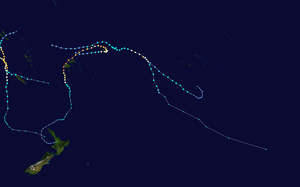
The 2012–13 South Pacific cyclone season was a below average tropical cyclone season, with six tropical cyclones occurring within the basin between 160°E and 120°W. The season officially ran from November 1, 2012 to April 30, 2013, however the last tropical disturbance was last noted on May 1, as it moved into the subtropics. During the season, tropical cyclones were officially monitored by the Fiji Meteorological Service (FMS), Australian Bureau of Meteorology (BoM) and New Zealand's MetService. The United States Joint Typhoon Warning Center (JTWC) and other national meteorological services including Météo-France and NOAA also monitored the basin during the season. During the season there were 22 significant tropical disturbances assigned a number and a F suffix by the FMS's Regional Specialized Meteorological Center in Nadi, Fiji (RSMC Nadi), including Severe Tropical Cyclone Sandra which moved into the basin from the Australian region on March 9. The BoM, MetService and RSMC Nadi all estimated sustained wind speeds over a period of 10-minutes and used the Australian tropical cyclone intensity scale, while the JTWC estimated sustained winds over a 1-minute period, which are subsequently compared to the Saffir–Simpson hurricane wind scale (SSHS).
Ahead of the cyclone season, RSMC Nadi, TCWC Wellington, the Australian Bureau of Meteorology (BoM), the New Zealand National Institute of Water and Atmospheric Research (NIWA) and various other Pacific Meteorological services, all contributed towards the Island Climate Update tropical cyclone outlook that was released during October 2012. The outlook took into account the ENSO neutral conditions and near normal sea surface temperature anomalies that had been observed across the Pacific. As a result, the outlook called for a near average number of tropical cyclones for the 2012–13 season, with nine to twelve named tropical cyclones predicted to occur between 135°E and 120°W compared to an average of 10. At least two of the tropical cyclones were expected to become category 3 severe tropical cyclones, while one might intensify into a category 4 severe tropical cyclone. The outlook also noted within past analogues, category 5 severe tropical cyclones had not been prominent for ENSO neutral seasons, but the most recent analogue suggested that this type of event was possible.
...
Wikipedia


