2011–12 South-West Indian Ocean cyclone season
| 2011–12 South-West Indian Ocean cyclone season |
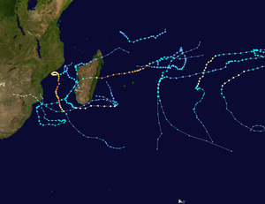
Season summary map
|
| Seasonal boundaries |
| First system formed |
December 4, 2011 |
| Last system dissipated |
June 8, 2012 |
| Strongest storm |
|
| Name |
Funso |
| • Maximum winds |
205 km/h (125 mph)
(10-minute sustained) |
| • Lowest pressure |
925 hPa (mbar) |
| Seasonal statistics |
| Total disturbances |
14 |
| Total depressions |
14 |
| Total storms |
10 |
| Tropical cyclones |
3 |
| Intense tropical cyclones |
2 |
| Total fatalities |
164 total |
| Total damage |
Unknown |
| Related articles |
|
|
South-West Indian Ocean tropical cyclone seasons
2009–10, 2010–11, 2011–12, 2012–13, 2013-14
|
| Moderate tropical storm (MFR) |
| Tropical storm (SSHWS) |
|
|
| Duration |
December 4 (entered basin) – December 7 (out of basin)
|
| Peak intensity |
85 km/h (50 mph) (10-min) 994 hPa (mbar) |
| Tropical depression (MFR) |
| Tropical storm (SSHWS) |
|
|
| Duration |
December 6 – December 9 |
| Peak intensity |
55 km/h (35 mph) (10-min) 998 hPa (mbar) |
| Subtropical depression (MFR) |
|
|
| Duration |
December 19 – December 23 |
| Peak intensity |
55 km/h (35 mph) (10-min) 1000 hPa (mbar) |
| Tropical cyclone (MFR) |
| Category 2 tropical cyclone (SSHWS) |
|
|
| Duration |
December 28 (entered basin) – January 4 |
| Peak intensity |
150 km/h (90 mph) (10-min) 968 hPa (mbar) |
| Moderate tropical storm (MFR) |
| Tropical storm (SSHWS) |
|
|
| Duration |
January 5 – January 10 |
| Peak intensity |
75 km/h (45 mph) (10-min) 992 hPa (mbar) |
| Subtropical depression (MFR) |
|
|
| Duration |
January 10 – January 16 |
| Peak intensity |
85 km/h (50 mph) (10-min) 992 hPa (mbar) |
| Severe tropical storm (MFR) |
| Category 1 tropical cyclone (SSHWS) |
|
|
| Duration |
January 17 – January 22 |
| Peak intensity |
100 km/h (65 mph) (10-min) 972 hPa (mbar) |
| Intense tropical cyclone (MFR) |
| Category 4 tropical cyclone (SSHWS) |
|
|
| Duration |
January 17 – January 28 |
| Peak intensity |
205 km/h (125 mph) (10-min) 925 hPa (mbar) |
| Intense tropical cyclone (MFR) |
| Category 4 tropical cyclone (SSHWS) |
|
|
| Duration |
February 7 – February 22 |
| Peak intensity |
195 km/h (120 mph) (10-min) 935 hPa (mbar) |
The 2011–12 South-West Indian Ocean cyclone season was an event in the annual cycle of tropical cyclone formation. It began on November 15, 2011, and ended on April 30, 2012, with the exception for Mauritius and the Seychelles, for which it ended on May 15, 2012. These dates conventionally delimit the period of each year when most tropical cyclones form in the region; however, Severe Tropical Storm Kuena developed in early June after the season had officially ended. The basin is defined as the area west of 90°E and south of the Equator in the Indian Ocean, which includes the waters around Madagascar westward to the east coast of Africa. Tropical cyclones in this basin are monitored by the Regional Specialised Meteorological Centre in Réunion.
On December 5, a rapidly developing area of low pressure crossed 90°E and entered La Réunion's area of responsibility. Within hours of moving into the region, the Joint Typhoon Warning Center (JTWC) classified it as Tropical Cyclone 01S. By this time, a banding eye feature was apparent on satellite imagery. Favorable atmospheric conditions allowed convection to increase in intensity and coverage over its center and good outflow. Several hours later, La Réunion reported that the system had intensified into a Moderate Tropical Storm, with the Mauritus Meteorological service naming it Alenga. The name was contributed by Kenya. Continuing to rapidly intensify, Alenga strengthened into a severe tropical storm later that day. Although predicted to intensify into a tropical cyclone, Alenga weakened near midday December 6, and was downgraded to moderate tropical storm status before it moved out of the South-West Indian Ocean (SWIO) and into the Australian region, early on December 7.
On December 6, Météo-France declared a tropical disturbance a tropical depression. On December 7, the cyclone entered an area of strong vertical wind shear causing the low level circulation centre to become exposed. Soon afterwards, Tropical Depression 02 dissipated to a remnant low. However, early on December 8, the system regenerated into a weak tropical depression. Later on December 8, convection redeveloped, and wrapped around the low level center, even as the storm continued moving westward, as it slowly weakened. Late on December 9, Météo-France issued their last advisory on the storm as it weakened below tropical depression intensity.However, the remnants continued to persist for the next several days with an exposed low level circulation center. But on December 16, the remnants dissipated completely in open waters, due to the high wind shear.
...
Wikipedia


.jpg)


