2007 Peru earthquake

Piles of rubble, one week after the shock
|
|

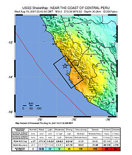
Map of the Peru coastline, showing location and strength of quake. Star marks epicenter.
|
|
| Date | August 15, 2007 |
|---|---|
| Origin time | 23:40:57 UTC |
| Magnitude | 8.0 Mw |
| Depth | 39 km (24 mi) |
| Epicenter | 13°21′14″S 76°30′32″W / 13.354°S 76.509°WCoordinates: 13°21′14″S 76°30′32″W / 13.354°S 76.509°W |
| Areas affected | Ica Region (Pisco, Ica and Chincha Alta) and Lima Region (San Vicente de Cañete) |
| Tsunami | flooded part of Lima's Costa Verde highway, and much of Pisco's shore |
| Casualties | 519 dead 1,366 injured |
The 2007 Peru earthquake, which measured 8.0 on the moment magnitude scale, hit the central coast of Peru on August 15 at 23:40:57 UTC (18:40:57 local time) and lasted for about three minutes. The epicenter was located 150 km (93 mi) south-southeast of Lima at a depth of 39 km (24 mi). The United States Geological Survey National Earthquake Information Center reported that it was a Very strong earthquake. The Peruvian government stated that 519 people were killed by the quake.
This earthquake occurred at the boundary between the Nazca and South American tectonic plates, which are converging at a rate of 78 mm (3.1 in) per year. The earthquake occurred as thrust faulting on the interface between the two plates, with the South American Plate moving up and seaward over the Nazca Plate. Experts say this kind of earthquake is produced about once every 100 years.
Coastal Peru has a history of very large earthquakes. The August 15th shock originated near the source of two previous earthquakes, both in the magnitude 8 range, which occurred in 1908 and 1974. This earthquake is south of the source of a magnitude 8.2 earthquake that occurred in northern Peru on October 17, 1966, and north of a magnitude 8.4 earthquake that occurred in 2001 near Arequipa in southern Peru. The largest earthquake along the coast of Peru was a magnitude 9 that occurred in 1868 in Arica. It produced a tsunami that killed several thousand people along the Peruvian coast and also caused damage in Hawaii.
...
Wikipedia
