Ica Region
| Ica Region | ||
|---|---|---|
| Region | ||

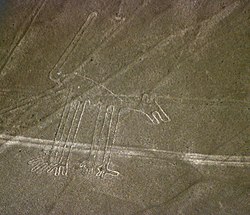
Nazca Lines: "Dog"
|
||
|
||
 Location of the Ica Region in Peru |
||
| Country | Peru | |
| Subdivisions | 5 provinces and 43 districts | |
| Capital | Ica | |
| Government | ||
| • President | Rómulo Triveño Pinto | |
| Area | ||
| • Total | 21,327.83 km2 (8,234.72 sq mi) | |
| Elevation(Capital) | 406 m (1,332 ft) | |
| Highest elevation | 3,796 m (12,454 ft) | |
| Lowest elevation | 0 m (0 ft) | |
| Population (2004 estimate) | ||
| • Total | 709,556 | |
| • Density | 33/km2 (86/sq mi) | |
| Dialing code | 056 | |
| ISO 3166 code | PE-ICA | |
| Principal resources | Iron, cotton, grapevine, kidney beans. | |
| Poverty rate | 41.7% | |
| Percentage of Peru's GDP | 2.36% | |
| Website | www.regionica.gob.pe | |
Ica (Quechua: Ika) is a region (formerly known as a department) in Peru. It borders the Pacific Ocean on the west; the Lima Region on the north; the Huancavelica and Ayacucho regions on the east; and the Arequipa Region on the south. Its capital is the city of Ica.
The Ica Region has a remarkable geography. It is the only region of the southern coast formed by plains, also called coast plains, since the Andean Cordillera rise up inland. Some geological folds have determined the formation of dunes moving toward the sea, which form much of the Paracas Peninsula. Some isolated formations located at the southern part created the Marcona complex, with the biggest deposits of iron in the Pacific coast.
Ica's configuration is due to the geomorphology of its two big and unique fluvial watersheds: the Pasco and Ica rivers. Also, it has a waterway called the Rio Grande, although its waters do not reach the ocean. Some waters are diverted for irrigation and agriculture in the provinces of Pampa, Nazca and Ingenio; the Rio Grande's final riverbed is dry since sand and dried lands absorb its limited resources. There are extensive deserts in Ica, such as the Lancha Pampas. Pozo Santo and Villacuri pampas are extremely hot areas. Strong and persistent winds called paracas are present and stir up large sandstorms.
...
Wikipedia

