2000–01 South-West Indian Ocean cyclone season
| 2000–01 South-West Indian Ocean cyclone season |

Season summary map
|
| Seasonal boundaries |
| First system formed |
August 1, 2000 |
| Last system dissipated |
June 24, 2001 |
| Strongest storm |
|
| Name |
Ando |
| • Maximum winds |
195 km/h (120 mph)
(10-minute sustained) |
| • Lowest pressure |
925 hPa (mbar) |
| Seasonal statistics |
| Total disturbances |
11 |
| Total depressions |
10 |
| Total storms |
6 |
| Tropical cyclones |
4 |
| Intense tropical cyclones |
2 |
| Total fatalities |
4 |
| Total damage |
Unknown |
| Related articles |
|
|
South-West Indian Ocean tropical cyclone seasons
1998–99, 1999–00, 2000–01, 2001–02, 2002–03
|
| Intense tropical cyclone (MFR) |
| Category 4 tropical cyclone (SSHWS) |
|
|
| Duration |
December 31 – January 9 |
| Peak intensity |
195 km/h (120 mph) (10-min) 925 hPa (mbar) |
| Tropical cyclone (MFR) |
| Category 3 tropical cyclone (SSHWS) |
|
|
| Duration |
January 3 – January 17 |
| Peak intensity |
150 km/h (90 mph) (10-min) 955 hPa (mbar) |
| Intense tropical cyclone (MFR) |
| Category 3 tropical cyclone (SSHWS) |
|
|
| Duration |
January 17 – January 31 |
| Peak intensity |
185 km/h (115 mph) (10-min) 930 hPa (mbar) |
| Tropical cyclone (MFR) |
| Category 2 tropical cyclone (SSHWS) |
|
|
| Duration |
March 4 – March 12 |
| Peak intensity |
150 km/h (90 mph) (10-min) 955 hPa (mbar) |
| Severe tropical storm (MFR) |
| Category 1 tropical cyclone (SSHWS) |
|
|
| Duration |
April 2 – April 8 |
| Peak intensity |
110 km/h (70 mph) (10-min) 973 hPa (mbar) |
| Moderate tropical storm (MFR) |
| Tropical storm (SSHWS) |
|
|
| Duration |
April 2 (entered basin) – April 5 |
| Peak intensity |
65 km/h (40 mph) (10-min) 998 hPa (mbar) |
| Subtropical storm (MFR) |
| Category 1 tropical cyclone (SSHWS) |
|
|
| Duration |
June 20 – June 24 |
| Peak intensity |
95 km/h (60 mph) (10-min) 995 hPa (mbar) |
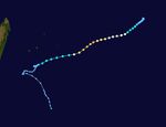
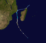
The 2000–01 South-West Indian Ocean cyclone season was fairly quiet with only five named storms, although there was an additional unnamed tropical storm and two subtropical cyclones with gale-force winds. It started early, with a tropical disturbance forming on August 1 – the first day of the cyclone year. However, the first named storm, Ando, was not named until January 2, which at the time was the 4th latest on record. Ando would become the most intense cyclone of the year, reaching peak winds of 195 km/h (120 mph) according to the Météo-France office (MFR) on Réunion, the official Regional Specialized Meteorological Center for the basin. The agency tracked storms south of the Equator and west of 90°E to the east coast of Africa.
In addition to being the strongest storm, Cyclone Ando was one of two deadly storms during the season. It passed about 205 km (105 mi) west of Réunion, producing 1,255 mm (49.4 in) of rainfall in the mountainous peaks. The rains led to flooding that killed two people. Ando was one of three storms to attain tropical cyclone status – winds of at least 120 km/h (75 mph) – in the month of January. The others were Bindu, which alternated its trajectory several times over open waters, and Charly, which rapidly weakened after encountering hostile wind shear. The next storm to form was Tropical Cyclone Dera, which intensified near Mozambique in early March and killed two people there due to flooding rains. It later moved southward through the Mozambique Channel, maintaining its intensity unusually far to the south before becoming extratropical. There was a month of inactivity in March, including three weeks in which there were no storms worldwide, the first such instance. Subsequently, two storms formed in early April; one was a small, unnamed tropical storm, and the other was Severe Tropical Storm Evariste, which brought light rainfall to two islands. The season ended with an unusual subtropical storm forming rapidly in the southern Mozambique Channel on June 19, the only such storm to form in that body of water in the month. It became the strongest storm on record for so late in the season, although it weakened without affecting land, dissipating on June 24.
...
Wikipedia


