1993–94 Australian region cyclone season
| 1993–94 Australian region cyclone season | |
|---|---|

Season summary map
|
|
| Seasonal boundaries | |
| First system formed | 14 December 1993 |
| Last system dissipated | 1 May 1994 |
| Strongest storm | |
| Name | Theodore |
| • Maximum winds | 200 km/h (125 mph) (10-minute sustained) |
| • Lowest pressure | 910 hPa (mbar) |
| Seasonal statistics | |
| Tropical lows | 11 |
| Tropical cyclones | 9 |
| Severe tropical cyclones | 9 |
| Total fatalities | 22 |
| Total damage | Unknown |
| Related articles | |
| Category 3 severe tropical cyclone (Australian scale) | |
| Tropical storm (SSHWS) | |
| Duration | 14 December – 18 December |
|---|---|
| Peak intensity | 140 km/h (90 mph) (10-min) 960 hPa (mbar) |
| Category 5 severe tropical cyclone (Australian scale) | |
| Category 4 tropical cyclone (SSHWS) | |
| Duration | 26 December – 21 January |
|---|---|
| Peak intensity | 205 km/h (125 mph) (10-min) 920 hPa (mbar) |
| Category 1 tropical cyclone (Australian scale) | |
| Tropical storm (SSHWS) | |
| Duration | 28 December – 9 January |
|---|---|
| Peak intensity | 65 km/h (40 mph) (10-min) 995 hPa (mbar) |
| Category 3 severe tropical cyclone (Australian scale) | |
| Category 1 tropical cyclone (SSHWS) | |
| Duration | January 10 – January 21 |
|---|---|
| Peak intensity | 120 km/h (75 mph) (10-min) 960 hPa (mbar) |
| Category 3 severe tropical cyclone (Australian scale) | |
| Category 1 tropical cyclone (SSHWS) | |
| Duration | 22 January – 29 January |
|---|---|
| Peak intensity | 150 km/h (90 mph) (10-min) 955 hPa (mbar) |
| Category 1 tropical cyclone (Australian scale) | |
| Tropical storm (SSHWS) | |
| Duration | 29 January – 31 January |
|---|---|
| Peak intensity | 85 km/h (50 mph) (10-min) 985 hPa (mbar) |
| Category 5 severe tropical cyclone (Australian scale) | |
| Category 4 tropical cyclone (SSHWS) | |
| Duration | 22 February – 28 February |
|---|---|
| Peak intensity | 200 km/h (125 mph) (10-min) 910 hPa (mbar) |
| Category 4 severe tropical cyclone (Australian scale) | |
| Category 3 tropical cyclone (SSHWS) | |
| Duration | 12 March – 22 March |
|---|---|
| Peak intensity | 190 km/h (115 mph) (10-min) 930 hPa (mbar) |
| Category 1 tropical cyclone (Australian scale) | |
| Tropical storm (SSHWS) | |
| Duration | 28 March – 3 April |
|---|---|
| Peak intensity | 65 km/h (40 mph) (10-min) 995 hPa (mbar) |
The 1993–94 Australian region cyclone season was a moderately active Australian cyclone season. It was also an event in the ongoing cycle of tropical cyclone formation. It ran from 1 November 1993 to 30 April 1994. The regional tropical cyclone operational plan also defines a tropical cyclone year separately from a tropical cyclone season, and the "tropical cyclone year" ran from 1 July 1993 to 30 June 1994.
Tropical cyclones in this area were monitored by four Tropical Cyclone Warning Centres (TCWCs): the Australian Bureau of Meteorology in Perth, Darwin, and Brisbane; and TCWC Port Moresby in Papua New Guinea.
Naomi was the first cyclone of the 1993/94 season. Forming early on 15 December 1993, the storm moved south and strengthened into a Category 3 before making landfall. There was moderate damage and a fishing boat was disabled during the storm. There were no deaths.
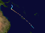
Cyclone Rewa formed on 26 December 1993. It looped around the Coral Sea for almost a month, crossed New Caledonia and the Solomon Island, and dissipated on 21 January. Rewa was the longest-lived South Pacific tropical cyclone on record, lasting 25 days, from 26 December to 21 January.
Cyclone Oscar was a weak system, and only barely reached cyclone strength on 3 January 1994 for about a 12-hour period. It moved on a generally west-southwest course parallel to the Kimberley and Pilbara coasts.
On January 11, a tropical low formed northwest of Broome, Western Australia. It was named Pearl a few hours later by the Bureau of Meteorology. The cyclone continued westward and reached a peak intensity of 155 km/h (100 mph). As the system moved west of 90°E, MFR took over warning responsibility on January 18 and renamed the cyclone Farah. At that time, MFR estimated winds of about 120 km/h (75 mph). After having moved westward due to a ridge to the south, Farah turned to the south upon entering the basin due to an approaching trough, which previously absorbed Edmea. High wind shear caused rapid weakening, and by January 19, there was little remaining convection. The next day, Farah weakened to tropical depression status and turned to the southeast. The ridge built behind the trough, causing the depression to stall and drift northward, and by February 22, Farah dissipated.
...
Wikipedia


