1924 Atlantic hurricane season
| 1924 Atlantic hurricane season |
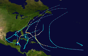
Season summary map
|
| Seasonal boundaries |
| First system formed |
June 18, 1924 |
| Last system dissipated |
November 24, 1924 |
| Strongest storm |
|
| Name |
"Cuba" |
| • Maximum winds |
165 mph (270 km/h) |
| • Lowest pressure |
910 mbar (hPa; 26.87 inHg) |
| Seasonal statistics |
| Total storms |
11 |
| Hurricanes |
5 |
Major hurricanes
(Cat. 3+) |
2 |
| Total fatalities |
≥150 |
| Total damage |
Unknown |
|
|
Atlantic hurricane seasons
1922, 1923, 1924, 1925, 1926
|
| Tropical storm (SSHWS) |
|
|
| Duration |
June 18 – June 21 |
| Peak intensity |
45 mph (75 km/h) (1-min) <1005 mbar (hPa) |
| Tropical storm (SSHWS) |
|
|
| Duration |
July 28 – July 30 |
| Peak intensity |
65 mph (100 km/h) (1-min) <999 mbar (hPa) |
| Category 3 hurricane (SSHWS) |
|
|
| Duration |
August 16 – August 26 |
| Peak intensity |
120 mph (195 km/h) (1-min) 963 mbar (hPa) |
| Category 2 hurricane (SSHWS) |
|
|
| Duration |
August 26 – September 3 |
| Peak intensity |
110 mph (175 km/h) (1-min) <965 mbar (hPa) |
| Category 1 hurricane (SSHWS) |
|
|
| Duration |
September 13 – September 17 |
| Peak intensity |
85 mph (140 km/h) (1-min) 980 mbar (hPa) |
| Tropical storm (SSHWS) |
|
|
| Duration |
September 20 – September 22 |
| Peak intensity |
45 mph (75 km/h) (1-min) ≤ 1005 mbar (hPa) |
| Tropical storm (SSHWS) |
|
|
| Duration |
September 24 – October 3 |
| Peak intensity |
50 mph (85 km/h) (1-min) <1007 mbar (hPa) |
| Tropical storm (SSHWS) |
|
|
| Duration |
September 27 – September 29 |
| Peak intensity |
65 mph (100 km/h) (1-min) ≤ 999 mbar (hPa) |
| Tropical storm (SSHWS) |
|
|
| Duration |
October 11 – October 15 |
| Peak intensity |
60 mph (95 km/h) (1-min) <1004 mbar (hPa) |
The 1924 Atlantic hurricane season featured the earliest known Category 5 hurricane – a tropical cyclone with maximum sustained winds exceeding 155 mph (250 km/h). The first system, Tropical Storm One, was first detected in the northwestern Caribbean Sea on June 18. The final system, an unnumbered tropical depression, dissipated on November 24. These dates fall within the period with the most tropical cyclone activity in the Atlantic. Of the 13 tropical cyclones of the season, six existed simultaneously. The season was average with 11 tropical storms, three of which strengthened into hurricanes. Further, two of those three intensified into major hurricanes, which are Category 3 or higher on the Saffir–Simpson hurricane wind scale.
The most significant storm of the season was Hurricane Ten, nicknamed the 1924 Cuba hurricane. It struck western Cuba as a Category 5 hurricane, before weakening and making landfall in Florida as a Category 1 hurricane. Severe damage and 90 fatalities were collectively reported at both locations. Another system, Hurricane Four, brought strong winds and flooding to the Leeward Islands. The storm left 59 deaths, 30 of which were on Montserrat alone. Several other tropical cyclones had minor impacts on land, including Tropical Storms One, Eight, and Ten, as well as Hurricanes Three and Five. Overall, the storms of the 1924 Atlantic hurricane season collectively caused at least 150 fatalities.
The season's activity was reflected with a low accumulated cyclone energy (ACE) rating of 100. ACE is, broadly speaking, a measure of the power of the hurricane multiplied by the length of time it existed, so storms that last a long time, as well as particularly strong hurricanes, have high ACEs. ACE is only calculated for full advisories on tropical systems at or exceeding 34 knots (39 mph, 63 km/h) or tropical storm strength.
A tropical storm was detected 75 miles (120 km) southeast of Chetumal, Quintana Roo on June 18. It made landfall on northern Belize with estimated winds near 45 mph (75 km/h). Pressures were progressively decreasing over the preceding days in the northwestern Caribbean Sea. The tropical system crossed the Yucatán Peninsula, emerging over the Bay of Campeche on June 19 with 40 mph (65 km/h) winds. It re-strengthened over water and re-attained winds of 45 mph (75 km/h). Early on June 21, the storm made landfall 115 miles (185 km) south of Tampico, Tamaulipas. It dissipated over land. The cyclone was classified as a weak disturbance, and strong winds were not recorded throughout the life span of the storm. Squalls affected the Texas coast, prompting advisories for small watercraft. Heavy rainfall was reported in Mexico.
...
Wikipedia


