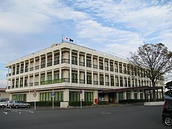
Ōkuma, Fukushima
|
Ōkuma 大熊町 |
|||
|---|---|---|---|
| Town | |||

Ōkuma Town Hall
|
|||
|
|||
 Location of Ōkuma in Fukushima Prefecture |
|||
| Coordinates: 37°24′16″N 140°59′1″E / 37.40444°N 140.98361°ECoordinates: 37°24′16″N 140°59′1″E / 37.40444°N 140.98361°E | |||
| Country | Japan | ||
| Region | Tōhoku | ||
| Prefecture | Fukushima | ||
| District | Futaba | ||
| Area | |||
| • Total | 78.70 km2 (30.39 sq mi) | ||
| Population (October 2016) | |||
| • Total | 0 | ||
| • Density | 0/km2 (0/sq mi) | ||
| Time zone | Japan Standard Time (UTC+9) | ||
| - Tree | Momi fir | ||
| - Flower | Nashi pear | ||
| - Bird | Black kite | ||
| Phone number | 0120-26-3844 | ||
| Address | Shimonogami Ōno 634, Ōkuma-machi, Futaba-gun, Fukushima-ken 979-1308 | ||
| Website | Official website | ||
Ōkuma (大熊町 Ōkuma-machi?) is a town located in Futaba District, Fukushima Prefecture, Japan. In 2010, the town had a population of 11,515 However, the town was totally evacuated in the aftermath of the Fukushima Daiichi nuclear disaster and residents have been permitted return during daylight hours from May 2013. As of November 2016, the town had an official registered population of 10,700, however this number is due to the municipality continuing to keep track of its residents despite them having been evacuated elsewhere throughout the country. The total area was 78.70 square kilometres (30.39 sq mi).
Ōkuma is located on the Pacific Ocean coastline of central Fukushima. Ōkuma lies in the center of the Hamadōri region of Fukushima, bordered to the west by the Abukuma Highlands and to the east by the Pacific Ocean. It is set between the cities of Namie and Futaba to the north, Tamura to the west, and Kawauchi and Tomioka to the south. The town is the site of the Fukushima Daiichi Nuclear Power Plant.
Mt. Higakure (日隠山 Higakure-yama), with a height of 601.5 meters, is within the city. The Kuma River (熊川 Kuma-gawa) also flows within the city.
...
Wikipedia


