Hamadōri
| Hamadōri (浜通り) | |
| Region | |
|
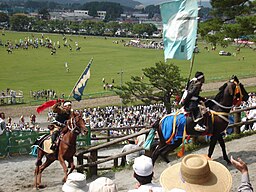
Riders at the Sōma-nomaoi festival, which is held annually in northern Hamadōri
|
|
| Country | Japan |
|---|---|
| Prefecture | Fukushima |
| Area | 2,969.11 km2 (1,146 sq mi) |
| Population | 538,136 (1 October 2010) |
| Density | 181/km2 (469/sq mi) |
|
Hamadōri comprises the eastern third of Fukushima Prefecture
|
|
Hamadōri (浜通り) is the easternmost of the three regions of Fukushima Prefecture in Japan, the other two being Nakadōri in the central area of the prefecture and Aizu in the west. Hamadōri is bordered by the Abukuma Highlands to the west and the Pacific Ocean to the east.
The principal city of the area is Iwaki.
In ancient Japan, the area currently known as Hamadōri served as a connecting route on the so-called Kaidō (海道, "Sea Road") route from Kinai in the central area of the country to Mutsu Province in northeastern Japan. The region that the road traversed also came to be known as Kaidō.
Following the implementation of the Ritsuryō system, the route's name was changed to Tōkaidō (東海道, "East Sea Road"). Despite the newly named Tōkaidō route extending up to Taga Castle in present-day Miyagi Prefecture, the region known as Tōkaidō extended only as far as the northernmost border of Hitachi Province, and the area of Hamadōri was considered a part of the Tōsandō region.
Following the conclusion of the Boshin War, the eastern section of present-day Fukushima Prefecture split off from Mutsu Province and formed Iwaki Province, the area of which included the Shirakawa District and the southern portion of modern-day Miyagi Prefecture, which the Shirakawa clan and Date clan, respectively, conquered during the Sengoku period.
...
Wikipedia


