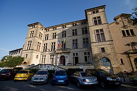
Éguilles
| Éguilles | ||
|---|---|---|
| Commune | ||

Town hall of Éguilles
|
||
|
||
| Coordinates: 43°34′10″N 5°21′17″E / 43.5694°N 5.3547°ECoordinates: 43°34′10″N 5°21′17″E / 43.5694°N 5.3547°E | ||
| Country | France | |
| Region | Provence-Alpes-Côte d'Azur | |
| Department | Bouches-du-Rhône | |
| Arrondissement | Aix-en-Provence | |
| Canton | Pélissanne | |
| Intercommunality | Aix-Marseille-Provence | |
| Government | ||
| • Mayor (2008–2014) | Robert Dagorne | |
| Area1 | 34.07 km2 (13.15 sq mi) | |
| Population (2008)2 | 7,604 | |
| • Density | 220/km2 (580/sq mi) | |
| Time zone | CET (UTC+1) | |
| • Summer (DST) | CEST (UTC+2) | |
| INSEE/Postal code | 13032 /13510 | |
| Elevation | 140–315 m (459–1,033 ft) (avg. 250 m or 820 ft) |
|
|
1 French Land Register data, which excludes lakes, ponds, glaciers > 1 km² (0.386 sq mi or 247 acres) and river estuaries. 2Population without double counting: residents of multiple communes (e.g., students and military personnel) only counted once. |
||
1 French Land Register data, which excludes lakes, ponds, glaciers > 1 km² (0.386 sq mi or 247 acres) and river estuaries.
Éguilles (French pronunciation: [eɡɥij]; Occitan: Agulha [aˈɣyʎɔ, aˈɡyjɔ]) is a commune in the Bouches-du-Rhône department in southern France. It is halfway between Saint-Cannat and Aix-en-Provence.
Tracks of an early settlement dating back to the 3rd century BC have been found. However, it appears that in 124BC those tracks were destroyed.
In the 16th century, there were attacks from Aix-en-Provence and Les Baux-de-Provence, and the Castle was destroyed. In 1790 there were 180 inhabitants, mostly shepherds.
In the 19th century many inhabitants left owing to the Industrial Revolution. By 1936 there were only 730 inhabitants.
The table below shows temperature and precipitation levels for 1971-2000 :
...
Wikipedia


