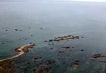
Écréhous

Aerial view of Les Écréhous.
|
|
| Geography | |
|---|---|
| Location | English Channel |
| Coordinates | 49°16′59″N 1°55′59″W / 49.283°N 1.933°WCoordinates: 49°16′59″N 1°55′59″W / 49.283°N 1.933°W |
| Major islands | Maîtr'Île La Marmotchiéthe Lé Bliantch'Île |
| Administration | |
|
Jersey
|
|
| Parish | Saint Martin, Jersey |
| Demographics | |
| Population | 0 |
The Écréhous (or Les Écréhou; in Jèrriais: Êcrého) are a group of islands and rocks situated six miles (9.6 km) north-east of Jersey, and eight miles (12.8 km) from France. They form part of the Bailiwick of Jersey and are administratively part of the Parish of St. Martin.
The most significant islets in the group are:
others include:
All but the three largest are submerged at high tide. There are no permanent residents on the islands and there is no fresh water there. Due to erosion, they are now much smaller than they may have been within historic times. Maîtr'Île, the largest of the islets, is about 300 metres (0.19 mi) long. There are a small number of fishermen's huts, some used as holiday residences, on the largest islets, and one official building, a customs house, on La Marmotchiéthe.
The name 'Écréhous' is Norse in origin. "Esker" as in Skerry meaning a stony bank and 'Hou', the toponym found also in Jethou, Lihou, Brecqhou, Burhou and other islets, derives from holm, meaning island. The first part of the name appears to be traced back to the Norse word sker, meaning reef. The Écréhous are actually, geologically, part of the same island group as Les Dirouilles (west) and Les Pierres de Lecq ('the Paternosters') (further west).
During the last Ice Age, sea levels were lower and the islands were high ground above a plain that connected the European Continent with southern England.
The islets, along with the other Channel Islands and the Cotentin Peninsula, were annexed to the Duchy of Normandy in 933. After William, Duke of Normandy conquered England in 1066 the islands remained united to the Duchy until the conquest of mainland Normandy in 1204 by Philip Augustus. In 1203, shortly before the division of Normandy in 1204, John, Duke of Normandy granted the Écréhous to the Abbey of Valricher that they might build a church there. In 1259 Henry III did homage to the French king for the Channel Islands. In 1309 it was reported that a prior was living in the Écréhous with one monk and a servant; a navigation light was lit every night. While Edward III in the 1360 Treaty of Brétigny waived his claims to the crown of France and to Normandy, he reserved various territories to England. In 1413 alien priories were suppressed and the monks returned to Valricher, and their church and priory on La Maîtr'Île fell into ruins. The chapel measured 10 feet 3 inches (3.12 m) in width and 16 feet 6 inches (5.03 m) in length; the priory accommodation for the monks formed an extension to the chapel.
...
Wikipedia

