West, Texas
| West, Texas | |
|---|---|
| City | |

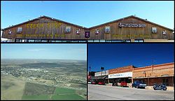
Top: Czech Stop & Little Czech Bakery, Bottom Left: Aerial view of the town of West, Texas — looking northeast, Bottom Right: View from Oak Street
|
|
| Nickname(s): Home of the Official Kolache of the Texas Legislature | |
 Location of West, Texas |
|
 |
|
| Coordinates: 31°48′12″N 97°5′35″W / 31.80333°N 97.09306°WCoordinates: 31°48′12″N 97°5′35″W / 31.80333°N 97.09306°W | |
| Country | United States |
| State | Texas |
| County | McLennan |
| Incorporated | 1892 |
| Government | |
| • Mayor | Tommy Muska |
| Area | |
| • Total | 1.6 sq mi (4.0 km2) |
| • Land | 1.6 sq mi (4.0 km2) |
| • Water | 0.0 sq mi (0.0 km2) |
| Elevation | 650 ft (198 m) |
| Population (2010) | |
| • Total | 2,807 |
| • Density | 1,754.3/sq mi (701.7/km2) |
| Time zone | Central (CST) (UTC-6) |
| • Summer (DST) | CDT (UTC-5) |
| ZIP code | 76691 |
| Area code(s) | 254, exchange 826 |
| FIPS code | 48-77332 |
| GNIS feature ID | 1349669 |
| Website | City Website |
West is a city in McLennan County, Texas, United States. As of the 2010 census, the city population was 2,807. It is named after T.M. West, the first postmaster of the city.
The city is located in the north-central part of Texas, approximately 70 miles south of the Dallas-Fort Worth Metroplex, 20 miles north of Waco and 120 miles north of Austin, Texas, the state's capital.
The first settlers of northern McLennan County arrived in the 1840s. They were farm and ranch families drawn from the east by the rich lands made available by the government sale of land to build schools in Texas. The area farmers cultivated the land and grew cotton, wheat, and grain sorghum, and raised cattle. The farming community centered around a freshwater spring that became known as Bold Springs. In 1860, Bold Springs had a population of about 300 and provided services such as a blacksmith, churches, and a post office.
The Missouri–Kansas–Texas Railroad was laid between Hillsboro and Waco in the fall of 1881. The path of the railroad passed through land owned by Thomas West, who had moved to the area in 1859. He farmed land that he had purchased and served as postmaster of Bold Springs. A train depot was built on the land he sold to the railroad company and the land running beside the tracks was divided into small sections and sold to people wanting to start businesses. The new depot included a post office, and from that time forward it was known as the West Post Office. Mr. West served as postmaster and opened the first general store. He became a successful businessman and later owned a hotel, a furniture store, and a bank.
The railroad brought prosperity to the area during the 1880s. More businesses were opened and more surrounding land was purchased. Czech immigrants came to the area, purchasing the rich lands to farm and start a fresh life in the new world. They also opened businesses, sharing their European culture. By the 1890s, the Czech businesses flourished in West. On June 11, 1892, West was officially organized into a town. It had become the center of commerce for the area. There were cotton gins, grocery stores, churches, schools, and doctors' offices.
...
Wikipedia
