| River Trent |
|
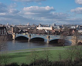
Trent Bridge, with Nottingham in the background
|
|
Name origin: Uncertain |
|
| Country |
United Kingdom |
| Country within the UK |
England |
| Counties |
Staffordshire, Derbyshire, Leicestershire, Nottinghamshire, Lincolnshire, Yorkshire
|
| Cities |
Stoke-on-Trent, Nottingham
|
| Towns |
Stone, Burton upon Trent, Newark-on-Trent, Gainsborough
|
|
| Tributaries |
| - left |
Blithe, Swarbourn, Dove, Derwent, Erewash, Leen, Greet, Idle, Torne
|
| - right |
Sow, Tame, Mease, Soar, Devon, Eau
|
|
|
| Source |
|
| - location |
Biddulph Moor, Staffordshire, England
|
| - elevation |
275 m (902 ft) |
| - coordinates |
53°07′05″N 2°08′36″W / 53.118011°N 2.14332°W / 53.118011; -2.14332 |
| Mouth |
|
| - location |
Trent Falls, Humber Estuary, Lincolnshire & Yorkshire, England
|
| - elevation |
0 m (0 ft) |
| - coordinates |
53°42′03″N 0°41′28″W / 53.700833°N 0.691111°W / 53.700833; -0.691111Coordinates: 53°42′03″N 0°41′28″W / 53.700833°N 0.691111°W / 53.700833; -0.691111 |
|
| Length |
298 km (185 mi) |
| Basin |
10,435 km2 (4,029 sq mi)
|
| Discharge |
for Colwick
|
| - average |
84 m3/s (2,966 cu ft/s)
|
| - max |
1,018 m3/s (35,950 cu ft/s)
|
| - min |
15 m3/s (530 cu ft/s)
|
| Discharge elsewhere (average) |
| - North Muskham
|
88 m3/s (3,108 cu ft/s) |
|
|
|
| |
|
| Progression : River Trent — Humber — North Sea
|


