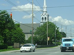
Orleans, Ontario
| Orleans | |
|---|---|
| Community | |
| Orléans | |

St-Joseph's Parish, built in 1830
|
|
| Country |
|
| Province |
|
| City |
|
| Parish of St-Joseph d'Orléans | 1830's |
| Police Village of St-Joseph d'Orléans | 1922 |
| Community of Orléans | 1974 |
| Government | |
| • Mayor | Jim Watson |
| • City councillors | Stephen Blais, Jody Mitic, Bob Monette |
| • Member of Parliament | Andrew Leslie, Francis Drouin |
| • Member of Provincial Parliament | Marie-France Lalonde, Grant Crack |
| Population (2011) | |
| • Total | 107,823 |
| Time zone | Eastern (EST) (UTC−5) |
| • Summer (DST) | EDT (UTC−4) |
| Area code(s) | Area code 613 |
Orleans (/ɔːrˈliːnz/; French: [ɔʁleɑ̃]), (officially Orléans), is a suburb of Ottawa, Ontario, Canada. It is located in the eastern part of the city along the Ottawa River, about 16 km (9.9 mi) from downtown Ottawa. The Canada 2011 Census determined that Orleans' population was 107,823. Prior to being amalgamated into Ottawa in 2001, the community of Orleans was spread over two municipal jurisdictions, the eastern portion being in the pre-amalgamation City of Cumberland, the western portion in the City of Gloucester. According to the 2011 census, 62,888 people lived in the Cumberland portion of Orleans, while 44,935 people lived in the Gloucester portion. Today, Orleans spans the municipal wards of Orleans, Innes and Cumberland. Orleans is one of 3 areas of the post-amalgamated City of Ottawa to contain a significant francophone population, hence the community's name.
The community is thought to have been named by its first postmaster, Théodore Besserer, after his place of birth, the Île d'Orléans near Quebec City. Orleans was an incorporated police village from 1922 to 1974 and was then known as St. Joseph d'Orléans. The name corresponds to the main francophone Roman Catholic Church, Paroisse St-Joseph of which the older part of Orleans is built around, along St-Joseph Boulevard.
...
Wikipedia
