Narvik
|
Narvik kommune Áhkanjárga |
|||
|---|---|---|---|
| Municipality | |||

Narvik
|
|||
|
|||
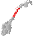
 Narvik within Nordland |
|||
| Coordinates: 68°25′14″N 17°33′36″E / 68.42056°N 17.56000°ECoordinates: 68°25′14″N 17°33′36″E / 68.42056°N 17.56000°E | |||
| Country | Norway | ||
| County | Nordland | ||
| District | Ofoten | ||
| Administrative centre | Narvik | ||
| Government | |||
| • Mayor (2011) | Tore Nysæter (H) | ||
| Area | |||
| • Total | 2,022.94 km2 (781.06 sq mi) | ||
| • Land | 1,905.72 km2 (735.80 sq mi) | ||
| • Water | 117.22 km2 (45.26 sq mi) | ||
| Area rank | 29 in Norway | ||
| Population (2012) | |||
| • Total | 18,473 | ||
| • Rank | 51 in Norway | ||
| • Density | 9.7/km2 (25/sq mi) | ||
| • Change (10 years) | −0.11 % | ||
| Demonym(s) | Narvikværing | ||
| Time zone | CET (UTC+1) | ||
| • Summer (DST) | CEST (UTC+2) | ||
| ISO 3166 code | NO-1805 | ||
| Official language form | Bokmål | ||
| Website | www |
||
|
|
|||
![]() Narvik (Norwegian) or Áhkanjárga (Northern Sami) is the third-largest town and municipality in Nordland county, Norway by population. The administrative centre of the municipality is the town of Narvik. Other villages in the municipality include Ankenesstranda, Beisfjord, Bjerkvik, Bjørnfjell, Elvegård, Skjomen, Håkvik, Hergot, Straumsnes, and Vidrek. The Elvegårdsmoen army camp is located near Bjerkvik.
Narvik (Norwegian) or Áhkanjárga (Northern Sami) is the third-largest town and municipality in Nordland county, Norway by population. The administrative centre of the municipality is the town of Narvik. Other villages in the municipality include Ankenesstranda, Beisfjord, Bjerkvik, Bjørnfjell, Elvegård, Skjomen, Håkvik, Hergot, Straumsnes, and Vidrek. The Elvegårdsmoen army camp is located near Bjerkvik.
Narvik is located on the shores of the Ofotfjorden. The municipality is part of the traditional district of Ofoten of Northern Norway, inside the Arctic Circle. The municipality of Narvik borders the municipality of Ballangen to the southwest, Evenes to the northwest, Bardu, Gratangen, Lavangen and Skånland (in Troms county) to the north, and Norrbotten County (Lapland) in Sweden to the south and east.
...
Wikipedia


