Jaraguá do Sul
| Jaraguá do Sul | |||
|---|---|---|---|

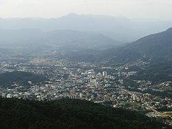
View of the city from Morro da Boa Vista
|
|||
|
|||
| Motto: Grandeza pelo Trabalho (Greatness through Work) | |||
| Coordinates: 26°29′S 49°04′W / 26.483°S 49.067°WCoordinates: 26°29′S 49°04′W / 26.483°S 49.067°W | |||
| Country |
|
||
| Region | South | ||
| State | Santa Catarina | ||
| Founded | July 25, 1876 | ||
| Government | |||
| • Mayor | Dieter Janssen (PP) | ||
| Area | |||
| • Total | 532.590 km2 (205.634 sq mi) | ||
| Elevation | 30 m (100 ft) | ||
| Population (2012) | |||
| • Total | 148,353 | ||
| • Density | 278.55/km2 (721.4/sq mi) | ||
| Time zone | UTC-3 (UTC-3) | ||
| • Summer (DST) | UTC-2 (UTC-2) | ||
| Website | Prefeitura Municipal de Jaraguá do Sul | ||
| HDI (2006) 0.850 – high | |||
Jaraguá do Sul (26°29′10″S 49°04′00″W / 26.48611°S 49.06667°W) is a city located in the north of the Brazilian state of Santa Catarina.
The city was founded on July 25, 1876 by engineer and Brazilian Army colonel Emílio Carlos Jourdan and his family. The city was originally named just Jaraguá, but it was later renamed to Jaraguá do Sul due to a city already named Jaraguá in Goiás state.
Jaraguá means Lord of the Valley in a Tupi–Guarani language. It was the name given by the indigenous population of the city to the Boa Vista Hill (Morro da Boa Vista).
It borders Campo Alegre and São Bento do Sul to the north; Blumenau, Massaranduba, Pomerode and Rio dos Cedros to the south; Guaramirim, Joinville and Schroeder to the east and Corupá to the west.
The Itapocu River is Jaraguá do Sul's important river, crossing the city, being Jaraguá River and Itapocuzinho River its main affluents.
...
Wikipedia


