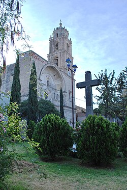
Zumpango de Ocampo
| Zumpango | ||
|---|---|---|
| Municipality | ||
| Zumpango | ||

Parish of Purísima Concepción
|
||
|
||
 |
||
| Location in Mexico | ||
| Coordinates: 19°47′49″N 99°05′57″W / 19.79694°N 99.09917°WCoordinates: 19°47′49″N 99°05′57″W / 19.79694°N 99.09917°W | ||
| Country |
|
|
| State | State of Mexico | |
| Municipal Status | 1820 | |
| Government | ||
| • Municipal President | Enrique Mazutti Delgado (2016-2018) | |
| Area | ||
| • Municipality | 244.08 km2 (94.24 sq mi) | |
| Elevationof seat | 2,261 m (7,418 ft) | |
| Population (2010)Municipality | ||
| • Municipality | 159,647 | |
| Time zone | CST (UTC-6) | |
| Postal code (of seat) | 55600 | |
| Area code(s) | 588 | |
| Website | (Spanish) Official site | |
Zumpango is a municipality located to northeastern part of the state of Mexico in Zumpango Region. It lies directly north of the Mexico City within the Greater Mexico City urban area. This area is under rapid development large scale housing projects; however, transportation and other infrastructure have not kept up with the growing population. The city of Zumpango lies near Lake Zumpango, the last of the five interconnected lakes which covered much of the Valley of Mexico in the pre Hispanic period. The name Zumpango is derived from the Nahuatl word “Tzompanco” which means string of scalps.
The municipality is located in the northeast part of the State of Mexico, part of the state’s panhandle that extends over the north and down on the east side of the Federal District of Mexico City. The municipality has a territory of 244.08km2 and borders the municipalities of Tequixquiac, Hueypoxtla, Teoloyucan, Cuautitán, Nextlapan, Jaltenco, Tecámac, Coyotepec and Huehuetoca as well as Tizayuca in the state of Hidalgo. Zumpango is considered to be part of the metropolitan area of Mexico City as part of the Cuautitlán-Texcoco zone north of the city proper.
About half of the territory is flat, mostly in the south with hills and small mountains in the north. The highest elevation is the Cerro del Zitlaltepec at 1650 meters above sea level. The main surface water is Lake Zumpango, which extends over 2,000 hectares. There are also some seasonal streams, the Gran Canal and other tunnels dug to drain the Valley of Mexico.
Lake Zumpango is the last of the five interconnected lakes that covered much of the Valley of Mexico in the pre Hispanic period. Since the 17th century, efforts to control flooding in Mexico City have worked to drain the lake system. The first effort was in 1607-1608, when a canal was dug to drain Lake Zumpango into the Tula River. It lowered lake levels but did not eliminate flooding. At the end of the 19th century a canal and tunnel brought water from the other lakes in the Valley, now disconnected, into Lake Zumpango. Further drainage efforts and over pumping of groundwater continued to dry Lake Zumpango until it disappeared in 1975. It was then decided to bring the lake back as a regulator, filling it with water from a new drainage canal called the Canal del Desague. This use of the lake was opposed by local people in 1983 and 1986 because of the dumping of wastewater, which led to compromises and infrastructure for irrigation. Today, the lake extends into neighboring Teoloyucan, , Melchor Ocampo, Hueypoxtla and Tequixquiac municipalities, but there is significant environmental issues because there is no agreement or declaration to protect the lake.
...
Wikipedia


