Zolfo Springs
| Zolfo Springs, Florida | |
|---|---|
| Town | |

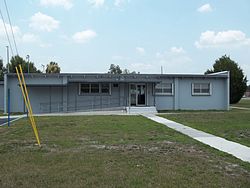
Zolfo Springs City Hall
|
|
 Location in Hardee County and the state of Florida |
|
| Coordinates: 27°29′46″N 81°47′49″W / 27.49611°N 81.79694°WCoordinates: 27°29′46″N 81°47′49″W / 27.49611°N 81.79694°W | |
| Country | United States |
| State | Florida |
| County | Hardee |
| Area | |
| • Total | 1.75 sq mi (4.52 km2) |
| • Land | 1.75 sq mi (4.52 km2) |
| • Water | 0.00 sq mi (0.00 km2) |
| Elevation | 66 ft (20 m) |
| Population (2010) | |
| • Total | 1,827 |
| • Estimate (2016) | 1,795 |
| • Density | 1,028.06/sq mi (396.89/km2) |
| Time zone | Eastern (EST) (UTC-5) |
| • Summer (DST) | EDT (UTC-4) |
| ZIP code | 33890 |
| Area code(s) | 863 |
| FIPS code | 12-79250 |
| GNIS feature ID | 0293628 |
| Website | www |
Zolfo Springs is a town in Hardee County, Florida, United States. The population was 1,827 at the 2010 census, up from 1,641 at the 2000 census.
Zolfo Springs is located at the geographic center of Hardee County, at 27°29′46″N 81°47′49″W / 27.49611°N 81.79694°W (27.496211, -81.796878).U.S. Route 17 runs through the center of town, leading north 4 miles (6 km) to Wauchula, the county seat, and south 20 miles (32 km) to Arcadia. Florida State Road 64 crosses the northern side of town, leading northeast 18 miles (29 km) to Avon Park and west 50 miles (80 km) to Bradenton. SR 66 leaves US 17 at the center of Zolfo Springs and leads east 25 miles (40 km) to U.S. Route 27 at the south end of Sebring.
According to the United States Census Bureau, Zolfo Springs has a total area of 1.7 square miles (4.5 km2), all of it land. The Peace River, which flows south to Punta Gorda, forms part of the northern town boundary. Pioneer Park Lake and Pioneer Park are also inside the town's boundaries. The tiny private Cracker Lake is also within the town.
...
Wikipedia
