Zoeterwoude-Dorp
| Zoeterwoude-Dorp | |
|---|---|
| Town | |

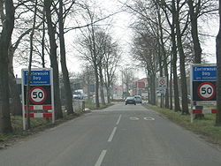
Eastern entrance to Zoeterwoude-Dorp, from the Nieuwe Weg
|
|
 |
|
 The town centre (red) and the statistical district (light green) of Zoeterwoude-Dorp in the municipality of Zoeterwoude. |
|
| Coordinates: 52°7′9″N 4°29′48″E / 52.11917°N 4.49667°ECoordinates: 52°7′9″N 4°29′48″E / 52.11917°N 4.49667°E | |
| Country | Netherlands |
| Province | South Holland |
| Municipality | Zoeterwoude |
| Area | |
| • Total | 119 ha (294 acres) |
| • Water | 3 ha (7 acres) |
| Population (2015) | |
| • Total | 4,205 |
| • Density | 3,500/km2 (9,200/sq mi) |
| Time zone | CET (UTC+1) |
| • Summer (DST) | CEST (UTC+2) |
| Postal code | 2381 |
| Dialing code | 071 580 |
Zoeterwoude-Dorp is a town in the Dutch province of South Holland. It is a part of the municipality of Zoeterwoude, and lies about 3.5 km south of Leiden. It has its origins in the 13th century, and even though the whole town went up in flames in the late 16th century, it was rebuilt within a hundred years and significantly expanded over the course of the 20th century.
Although signs of human settlement in the Zoeterwoude region were dated to as early as the 8th century in the vicinity of present-day Weipoort, a village on the current location of Zoeterwoude-Dorp was not constructed until about 1276 when the mire in the area was cultivated. A Catholic church from the earlier village dedicated to the English missionary Saint Lebuinus was rebuilt in what was then called "Zwieterwoude".
Over the course of the centuries, the village was constructed with this Lebuinus church as its center. In the 15th century, the northern part of town became known as "Noordbuurt" (English: Northern Neighbourhood).
In 1574, Zoeterwoude-Dorp was burnt down by the neighbouring town of Leiden. Leiden did this in order to protect itself against the Spanish in the Eighty Years' War, which had come to envelope the entire country. The town was rebuilt by 1650.
During the 19th century, the town saw some changes. The Dorpsstraat (English: Town Street) was outfitted with nine new houses in 1828, while in 1866 a cow bush (a burial place for cows that died of anthrax – a disease to which the town was no stranger) was removed. In 1870 the town hall was moved from a rental building at the Hoge Rijndijk (English: High Rijn Causeway) to a new building at its present location at the Noordbuurtseweg.
In the 20th century, the town was expanded significantly. After World War II, three new neighbourhoods named Westwout, Vogelweide and Bloemenweide were built on the west side of the town, giving the town its current function as the heart of the Zoeterwoude municipality, and a residential center.
Attempts to discover more information about the origins of the town were thwarted in October 1981, when an archaeological survey in the centre of the town failed to unveil anything of note.
...
Wikipedia
