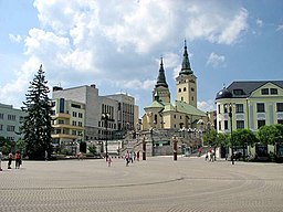
Zilina
| Žilina | |||
| City | |||
|
Andrej Hlinka Square
|
|||
|
|||
| Country | Slovakia | ||
|---|---|---|---|
| Region | Žilina | ||
| District | Žilina | ||
| Tourism region | Horné Považie | ||
| Rivers | Váh, Rajčanka, Kysuca | ||
| Center | Andrej Hlinka Square | ||
| - elevation | 342 m (1,122 ft) | ||
| - coordinates | 49°13′22″N 18°44′24″E / 49.22278°N 18.74000°ECoordinates: 49°13′22″N 18°44′24″E / 49.22278°N 18.74000°E | ||
| Area | 80.028 km2 (30.90 sq mi) | ||
| Population | 81,155 (2014-12-31) | ||
| - urban | 108,114 | ||
| - metro | 154,000 | ||
| Density | 1,014/km2 (2,626/sq mi) | ||
| First mentioned | 1208 | ||
| Mayor | Igor Choma | ||
| Timezone | CET (UTC+1) | ||
| - summer (DST) | CEST (UTC+2) | ||
| Postal code | 010 01 | ||
| Area code | +421-41 | ||
| Car plate | ZA | ||
| Statistics: MOŠ/MIS | |||
| Website: www.zilina.sk | |||
Žilina (Slovak pronunciation: [ˈʒilina]; German: Sillein, [ziˈlaɪ̯n] or [ˈzɪlaɪ̯n]; Hungarian: Zsolna; Polish: Żylina, names in other languages) is a city in north-western Slovakia, around 200 kilometres (120 mi) from the capital Bratislava, close to both the Czech and Polish borders. It is the fourth largest city of Slovakia with a population of approximately 85,000, an important industrial center, the largest city on the Váh river, and the seat of a kraj (Žilina Region) and of an okres (Žilina District). It belongs to the Upper Váh region of tourism.
The name is derived from Slavic/Slovak word žila - a "(river) vein". Žilina means "a place with many watercourses". Alternatively, it is a secondary name derived from Žilinka river or from the name of the local people, Žilín/Žiliňane.
The area around today's Žilina was inhabited in the late Stone Age (about 20,000 BC). In the 5th century Slavs started to move into the area. However, the first written reference to Žilina was in 1208 as terra de Selinan. From the second half of the 10th century until 1918, it was part of the Kingdom of Hungary.
...
Wikipedia


