Ziebach County
| Ziebach County, South Dakota | |
|---|---|

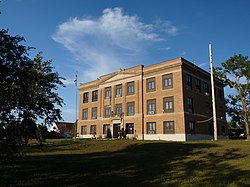
Ziebach County Courthouse
|
|
 Location in the U.S. state of South Dakota |
|
 South Dakota's location in the U.S. |
|
| Founded | 1911 |
| Named for | Frank M. Ziebach |
| Seat | Dupree |
| Largest city | Dupree |
| Area | |
| • Total | 1,971 sq mi (5,105 km2) |
| • Land | 1,961 sq mi (5,079 km2) |
| • Water | 9.3 sq mi (24 km2), 0.5% |
| Population (est.) | |
| • (2016) | 2,801 |
| • Density | 1.4/sq mi (1/km²) |
| Congressional district | At-large |
| Time zone | Mountain: UTC-7/-6 |
Ziebach County is a county located in the U.S. state of South Dakota. As of the 2010 census, the population was 2,801. Its county seat is Dupree. It is the last county in the United States alphabetically.
The county's per-capita income makes it the fourth poorest county in the United States. However, another study states that the county is the poorest in the nation.
Ziebach County was created in 1911, encompassing parts of the former counties of Schnasse, Armstrong and Sterling, which were the last three extinct counties of South Dakota to cease to exist. It was named for Frank M. Ziebach, a noted political figure in the Dakota Territory during the territorial period from 1861 to 1889. Previously the area had been used by trappers and in 1907 part was briefly a reservation for Ute Indians displaced from Utah and Wyoming. Early in the 20th Century cattle were raised in substantial numbers, but when the railroad bypassed the area this industry declined. Limited homesteading also occurred on the more fertile lands.
According to the U.S. Census Bureau, the county has a total area of 1,971 square miles (5,100 km2), of which 1,961 square miles (5,080 km2) is land and 9.3 square miles (24 km2) (0.5%) is water. Almost the entire county lies within the Cheyenne River Indian Reservation. The balance of the county, along its extreme northern county line, lies within the Standing Rock Indian Reservation. It is one of five South Dakota counties that lie entirely on Indian reservations.
...
Wikipedia
