Zeals
| Zeals | |
|---|---|
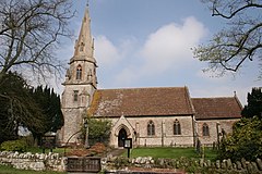
 St. Martin's parish church |
|
| Zeals shown within Wiltshire | |
| Population | 658 (2011) |
| OS grid reference | ST780317 |
| Civil parish |
|
| Unitary authority | |
| Ceremonial county | |
| Region | |
| Country | England |
| Sovereign state | United Kingdom |
| Post town | Warminster |
| Postcode district | BA12 |
| Dialling code | 01747 |
| Police | Wiltshire |
| Fire | Dorset and Wiltshire |
| Ambulance | South Western |
| EU Parliament | South West England |
| UK Parliament | |
Zeals is a village and civil parish in southwest Wiltshire, England. The village is about 2.2 miles (3.5 km) west of Mere, next to the A303 road towards Wincanton, and adjoins the villages of Bourton, Dorset and Penselwood, Somerset. Its name comes from the Old English sealh meaning a small willow or sallow.
The civil parish includes the hamlets of Long Cross, White Cross, Lower Zeals and Wolverton.
There is archaeological evidence of human activity in Zeals as far back as neolithic times. The village borders the western edge of Salisbury Plain, and is 23 miles (37 km) from Stonehenge. There are bowl barrows on Mappledine Hill in the south east corner of the parish, and early prehistoric activity at Pen Pits to the north which were quarried since Roman times for greensand querns for hand grinding corn.
In 1086 the Domesday Book recorded that the area of Zeals consisted of two estates: Lower Zeals (later the Manor of Zeals, or Clevedon) and Higher Zeals (later Zeals Aylesbury). Estimates suggest a population of around 40–50 at Lower Zeals and 85–95 at Higher Zeals at that time.
Zeals House is a Grade I listed country house dating from the 14th century, with many later additions. It was owned by the Chafyn family, later the Chafyn-Groves, from the 15th century until the mid 20th century; in 1897 the family were benefactors of Chafyn Grove School near Salisbury.
Zeals has a set of Tudor revival-style almshouses that were built in 1865 for William Chafyn-Grove. Together with the parish hall, they are Grade II listed.
...
Wikipedia

