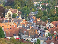
Mere, Wiltshire
| Mere | |
|---|---|
 |
|
| Mere shown within Wiltshire | |
| Population | 2,961 (in 2011) |
| OS grid reference | ST812322 |
| Civil parish |
|
| Unitary authority | |
| Ceremonial county | |
| Region | |
| Country | England |
| Sovereign state | United Kingdom |
| Post town | WARMINSTER |
| Postcode district | BA12 |
| Dialling code | 01747 |
| Police | Wiltshire |
| Fire | Dorset and Wiltshire |
| Ambulance | South Western |
| EU Parliament | South West England |
| UK Parliament | |
| Website | Town Council |
Mere is a small town and civil parish in Wiltshire, England. It lies at the extreme southwestern tip of Salisbury Plain, close to the borders of Somerset and Dorset. The parish includes the hamlets of Barrow Street, Burton, Charnage, Limpers Hill, Rook Street and Southbrook.
The A303 trunk road passed through Mere until a bypass was built on the northern edge of the town in 1976.
There is an old market square (although markets have not been held for several years), a chiming town clock and a large 15th-century parish church. The steep slope of Castle Hill rises from the northwestern side of Mere. Local industry and commerce includes the Hill Brush company, large wholesale plant nurseries and Yapp's wine merchants.
Evidence of prehistoric activity in the area is provided by bowl barrows, including four on Long Hill, overlooking the town. On the northwestern boundary of the parish is Whitesheet Hill, with barrows and an Iron Age hill fort, White Sheet camp.
Mere had a church from the end of the 12th century. The Earl of Cornwall built Mere Castle on Long Hill, overlooking the town, in the mid-13th century. The castle was abandoned in the 14th century and today only earthworks remain. The Duchy of Cornwall still owns much land in the area.
Mere Down, north of the town, has medieval Strip lynchets.
The civil parish elects a town council. It is in the area of Wiltshire Council unitary authority, which performs most significant local government functions.
...
Wikipedia

