Zarnuqa
| Zarnuqa | |
|---|---|

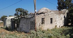
Village mosque in 2016.
|
|
| Arabic | زرنوقة |
| Name meaning | "The rivulet" |
| Subdistrict | Ramle |
| Coordinates | 31°52′49″N 34°47′23″E / 31.88028°N 34.78972°ECoordinates: 31°52′49″N 34°47′23″E / 31.88028°N 34.78972°E |
| Palestine grid | 130/143 |
| Population | 2,380 (1945) |
| Area | 7,545 dunams |
| Date of depopulation | 27–28 May 1948 |
| Cause(s) of depopulation | Expulsion by Yishuv forces |
| Current localities | Rehovot, Kvutzat Shiller, Gibton and Givat Brenner |
Zarnuqa (Arabic: زرنوقة), also Zarnuga, was a Palestinian Arab village in the Ramle Subdistrict. It was depopulated on 27–28 May 1948 during the 1948 Arab–Israeli War.
Zarnuqa was located 10 km southwest of Ramla.
Ceramics from the Late Bronze Age and the Persian era have been found here.
Building, winepress and ceramics from the Byzantine era have been found, as have early Islamic remains.
Tombs, from Late Ottoman period (sixteenth–nineteenth centuries CE) have been excavated, as has a building with a kiln and pottery dating to the eighteenth–nineteenth centuries.
The mosque of the village was built by Shaykh Ahmad al-Rahhal. A two-line poem inscribed in nashki script, dated the construction of the mosque to 1207 H. (1792-1793 C.E.).
The village appeared as an unnamed village on the map of Pierre Jacotin compiled in 1799. Some of the inhabitants of Zarnuqa were Egyptians who arrived in Palestine with the army of Ibrahim Pasha. In 1838, Zernukah was noted as a village in the Gaza area.
In 1863 Victor Guérin found that Zarnuqa had 300 inhabitants, and that it was surrounded by tobacco plantations. A sanctuary was dedicated to a Sheik Mohammed.
An Ottoman village list of about 1870 counted 107 houses and a population of 267, though the population count included men only. Passing by, in 1871, Charles Warren described travelling in the area: "We passed through olive groves and gardens past Zernuka, until crossing over some undulating hills we came across the village Akir..."
...
Wikipedia

