Zagnanado
| Zagnanado | |
|---|---|
| Commune and city | |

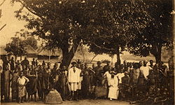
Missionaries in Zagnanado, c.1910s
|
|
| Location in Benin | |
| Coordinates: 7°16′N 2°21′E / 7.267°N 2.350°E | |
| Country |
|
| Department | Zou Department |
| Area | |
| • Total | 290 sq mi (750 km2) |
| Population (2013) | |
| • Total | 132,401 |
| Time zone | WAT (UTC+1) |
Zagnanado or Zangnanado is a town, arrondissement, and commune in the Zou Department of southern-central Benin. It is located 47 kilometres from Abomey and 165 kilometres north of Cotonou. The commune covers an area of 750 square kilometres and as of 2013 had a population of 132,401 people.
The territorial entity that is today the municipality of Zagnanado has undergone several administrative changes since the colonial period until today. Since the early eighteenth century, the region depended on the kingdom of Abomey. Guézo made the area headquarters of the army during his campaigns against the Yoruba and Kétou of Abeokuta. By the Act of June 21, 1895, King Agoli-Agbo, he authorised full authority over the Agonlin region. In the early twentieth century, Zagnanado and surrounding villages were visited by many missionaries who spread Christianity. During the colonial period and into the 1970s, Agonlin remained a single administrative entity. However, in 1978 it was divided into three communes, Zagnanado, Covè and Ouinhi.
3 rivers flow through the commune, the longest flows through for 93 kilometers. Zagnanado is bordered by Dassa-Zoumè to the north, Ouinhi and Zogbodomè to the south, Covè, Za-Kpota and Djidja to the west and Adja-Ouèrè and Kétou to the east.
Zagnanado is subdivided into six arrondisements,Agonlin-Houégbo, Banami, Don Tan, Dovi, Kpedekpo and Zagnanado. They contain 27 villages and 7 city districts.
...
Wikipedia

