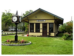
Zachary, Louisiana
| Zachary, Louisiana | |
| City | |
|
Zachary Railroad Depot
|
|
| Country | United States |
|---|---|
| State | Louisiana |
| Parish | East Baton Rouge |
| Elevation | 102 ft (31.1 m) |
| Coordinates | 30°39′18″N 91°09′24″W / 30.65500°N 91.15667°WCoordinates: 30°39′18″N 91°09′24″W / 30.65500°N 91.15667°W |
| Area | 23.96 sq mi (62.1 km2) |
| - land | 23.93 sq mi (62 km2) |
| - water | 0.03 sq mi (0 km2), 0.13% |
| Population | 14,960 (2010) |
| Density | 625.1/sq mi (241.4/km2) |
| Timezone | CST (UTC-6) |
| - summer (DST) | CDT (UTC-5) |
| ZIP code | 70791 |
| Area code | 225 Exchanges: 654,658 |
|
Location in East Baton Rouge Parish and the state of Louisiana
|
|
|
Website: www |
|
Zachary is a city in the East Baton Rouge parish of Louisiana in the United States. It lies 16 miles (26 km) north of the city of Baton Rouge, and had a population of 14,960 at the 2010 census, up from 11,275 at the 2000 census.
Much of the land which the city now occupies was part of a 160-acre (65 ha) farm owned by Darel Zachary (1827-1907). In the 1880s, Zachary sold his land to the Illinois Central Railroad, who built a track and a depot on it. A village quickly grew up around the depot, which came to be called "Zachary" after the original farmer. Zachary's first post office was opened in 1885, and it was incorporated as a city on August 2, 1889, with Thomas Edward McHugh as its first mayor. A fire devastated the city in 1903, supposedly caused by a greengrocer trying to flame-ripen his bananas. The "historic village" at the center of the city is composed of buildings which either survived the fire, or were built shortly after it, the oldest (excluding the depot) being the 1898 Allison House. The first census was carried out in 1914 and reported just 419 residents. Zachary was the first city in Louisiana since the Reconstruction Era to elect a Republican as mayor, Jack Louis Breaux.
Zachary is located in northern East Baton Rouge Parish. It is bordered to the north by the city of Slaughter, to the east by Central, and to the south by Baker. Louisiana Highway 19 passes through the city, leading north 5 miles (8 km) to the center of Slaughter and south 9 miles (14 km) to U.S. Route 61 in the northern part of Baton Rouge.
According to the United States Census Bureau, Zachary has a total area of 24.0 square miles (62.1 km2), of which 23.9 square miles (62.0 km2) is land and 0.04 square miles (0.1 km2), or 0.13%, is water.
...
Wikipedia


