Yoron Island
| Japanese: Yoronjima (与論島?) Okinawan: Yunnu (ユンヌ?) Kunigami: Yunnuu (ユンヌー?) |
|
|---|---|

Aerial view of Yoronjima in 2008
|
|
 |
|
| Geography | |
| Location | East China Sea |
| Coordinates | 27°22′08″N 128°34′00″E / 27.36889°N 128.56667°ECoordinates: 27°22′08″N 128°34′00″E / 27.36889°N 128.56667°E |
| Archipelago | Amami Islands |
| Area | 20.8 km2 (8.0 sq mi) |
| Coastline | 23.5 km (14.6 mi) |
| Highest elevation | 98 m (322 ft) |
| Administration | |
|
Japan
|
|
| Prefectures | Kagoshima Prefecture |
| District | Ōshima District |
| Demographics | |
| Population | 6,000 (2013) |
| Ethnic groups | Japanese |
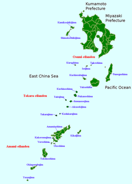
Yoronjima (与論島?, Okinawan: ユンヌ Yunnu; Kunigami: ユンヌー Yunnuu) is one of the Amami Islands.
The island, 20.8 km² in area, has a population of approximately 6,000 persons, and is administered as the town of Yoron, Kagoshima. Much of the island is within the borders of the Amami Guntō Quasi-National Park.
Yoronjima is the southernmost of the Amami Islands and is located approximately 22 kilometres (12 nmi) north of Hedo Point, the northernmost point of Okinawa Island. and 563 kilometres (304 nmi) south of the southern tip of Kyūshū.
The island is an elevated coralline island with a highest point 97 metres (318 ft) above sea level. The coast of the island is surrounded by a coral reef.
Yoronjima has a humid subtropical climate (Köppen climate classification Cfa) with very warm summers and mild winters. Precipitation is significant throughout the year, but is somewhat lower in winter. The island is subject to frequent typhoons.
It is uncertain when Yoronjima was first settled. It was ruled by the Aji nobility from the 8th century onwards . From 1266 it was part of the Hokuzan Ryukyu Kingdom. The island was invaded by samurai from Satsuma Domain in 1609 and its incorporation into the official holdings of that domain was recognized by the Tokugawa shogunate in 1624. Satsuma rule was harsh, with the inhabitants of the island reduced to serfdom and forced to raise sugar cane to meet high taxation, which often resulted in famine.
...
Wikipedia
