Yonaguni, Okinawa
|
Yonaguni 与那国町 Dunan |
|||||||
|---|---|---|---|---|---|---|---|
| Town | |||||||
Yonaguni Montage
|
|||||||
|
|||||||
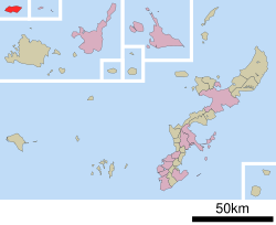
 Location of Yonaguni in Okinawa Prefecture |
|||||||
| Location in Japan | |||||||
| Coordinates: 24°28′5″N 123°0′17″E / 24.46806°N 123.00472°ECoordinates: 24°28′5″N 123°0′17″E / 24.46806°N 123.00472°E | |||||||
| Country | Japan | ||||||
| Region | Kyushu (Okinawa) | ||||||
| Prefecture | Okinawa Prefecture | ||||||
| District | Yaeyama | ||||||
| Government | |||||||
| • Mayor | Shukichi Hokama | ||||||
| Area | |||||||
| • Total | 28.95 km2 (11.18 sq mi) | ||||||
| Population (October 1, 2016) | |||||||
| • Total | 2,048 | ||||||
| • Density | 58.2/km2 (151/sq mi) | ||||||
| Symbols | |||||||
| • Tree | Chinese fan palm (Livistona chinensis) | ||||||
| • Flower | Lily (Lilium) | ||||||
| • Bird | Japanese white-eye (Zosterops japonicus) | ||||||
| • Flowering tree | Crape myrtle (Lagerstroemia) | ||||||
| • Butterfly | Atlas moth (Attacus atlas) | ||||||
| Time zone | Japan Standard Time (UTC+9) | ||||||
| City hall address | 129 Aza-Yonaguni, Yonaguni-chō, Yaeyama-gun, Okinawa-ken 907-1801 |
||||||
| Website | www |
||||||
Yonaguni (与那国町 Yonaguni-chō?, Yonaguni: Dunan, Yaeyama: Yunōn, Okinawan: Yunaguni) is a town located entirely on Yonaguni Island in Yaeyama District, Okinawa Prefecture, Japan. It is the westernmost municipality in Japan, and is known for billfish fishing and as a diving spot. In 1987, divers discovered the Yonaguni Monument, a rock formation that some believe may be man-made.
It is also home to two Ryūkyūan writing systems, pictographic "kaida-di" (also used on Ishigaki and Taketomi islands where it is called "kaida-ji") and the symbols used to indicate family names, "dāhan" (also used on Ishigaki Island where they are called "yāban").
Presently, the oldest confirmed ruins are the Tuguru Beach ruins. Due to the southern style stone tools found, it is thought that a culture influenced by Southeast Asia existed here at one time.
After this point, the history of the island of Yonaguni is unclear, but in the Gusuku Era, settlements were formed on the top of the plateau. The Shima Nakamura Ruins are one example, and it is known for being the birth village of the famous woman chief, San’ai Isoba.
From the time of the Ryūkyū Kingdom, Yonaguni prospered as a commerce center with Taiwan. Due to World War II, until it was placed under control of the United States Civil Administration of the Ryukyu Islands, the number of people involved in smuggling surged in the area. The population in 1947 had reached 12,000, but although Yonaguni became incorporated as a town, a crackdown on smuggling led to a sharp decrease in the population.
...
Wikipedia


