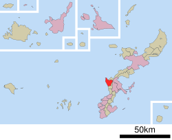
Yomitan, Okinawa
|
Yomitan 読谷村 Yuntan |
||
|---|---|---|
| Village | ||
|
||
 Location of Yomitan in Okinawa Prefecture |
||
| Location in Japan | ||
| Coordinates: 26°23′46″N 127°44′40″E / 26.39611°N 127.74444°ECoordinates: 26°23′46″N 127°44′40″E / 26.39611°N 127.74444°E | ||
| Country | Japan | |
| Region | Kyushu | |
| Prefecture | Okinawa Prefecture | |
| District | Nakagami | |
| Government | ||
| • Mayor | Denjitsu Ishimine | |
| Area | ||
| • Total | 35.17 km2 (13.58 sq mi) | |
| Population (December 2012) | ||
| • Total | 40,517 | |
| • Density | 1,200/km2 (3,000/sq mi) | |
| Time zone | Japan Standard Time (UTC+9) | |
| Website | web |
|
Yomitan (読谷村 Yomitan-son?, Okinawan: Yuntan) is a village located in Nakagami District, Okinawa Prefecture, Japan.
Yomitan is located on the western coast of the central part of Okinawa Island. The village is bound to the north by Onna, to the east by Okinawa City, to the south by Kadena, and to the west by the East China Sea.
31.5% of the land area is zoned for agriculture, 35.7% is zoned as forest, 12.3% is zoned for housing, and the remaining 20.6% is zoned for other uses.
Originally known as Yomitanzan (読谷山?, Okinawan: Yutanza), it was part of the Kingdom of Chūzan during the Sanzan period. In 1416, the Aji of Yomitanzan Magiri, Gosamaru, helped Shō Hashi invade Hokuzan. Although Gosamaru lived in Yamada Castle, Shō Hashi allowed him to build Zakimi Castle. The castle, along with other castle sites in Okinawa, was designated a World Heritage Site by UNESCO in November 2000. The port of Hamanaga, which was located in the north of Yomitanzan, was an important center of Nanban, or "southern barbarian", trade of the Ryukyu Kingdom. Yomitanzan was also the site of a landing during the Invasion of Ryukyu by Satsuma Domain in 1609. After Japan annexed Ryukyu in 1879, Yomitanzan continued to be a magiri; all of the magiri were abolished in 1907 and Yomitanzan became a village.
...
Wikipedia


