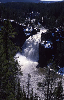
Yellowstone Falls
| Upper Yellowstone Falls | |
|---|---|
 |
|
| Location | Yellowstone National Park, Park County, Wyoming, United States |
| Coordinates | 44°42′46″N 110°29′59″W / 44.71278°N 110.49972°W |
| Total height | 109 feet (33 m) |
| Watercourse | Yellowstone River |
| Lower Yellowstone Falls | |
|---|---|
 |
|
| Location | Yellowstone National Park |
| Coordinates | 44°43′05″N 110°29′46″W / 44.71806°N 110.49611°W |
| Total height | 308 feet (94 m) |
| Watercourse | Yellowstone River |
Yellowstone Falls consist of two major waterfalls on the Yellowstone River, within Yellowstone National Park, Wyoming, United States. As the Yellowstone river flows north from Yellowstone Lake, it leaves the Hayden Valley and plunges first over Upper Yellowstone Falls and then a quarter mile (400 m) downstream over Lower Yellowstone Falls, at which point it then enters the Grand Canyon of the Yellowstone, which is up to 1,000 feet (304 m) deep.
The upper falls (44°42′46″N 110°29′59″W / 44.71278°N 110.49972°W) are 109 feet (33 m) high. The brink of the upper falls marks the junction between a hard rhyolite lava flow and weaker glassy lava that has been more heavily eroded.
Cascading from the 590,000 year old Canyon Rhyolite lava flow, Lower Yellowstone Falls is the largest volume waterfall in the Rocky Mountains of the United States. These falls (44°43′05″N 110°29′46″W / 44.71806°N 110.49611°W) are 308 feet (94 m) high, or nearly twice as high as Niagara Falls. The volume of water flowing over Lower Yellowstone Falls can vary from 680 cu ft/s (19 m3/s) in the autumn, to 8,400 cu ft/s (240 m3/s) at peak runoff in late springtime. The flow rate of Lower Yellowstone Falls is much less than that of Niagara Falls, as the Yellowstone River is only 70 feet (21 m) at the point at which it goes over the lower falls, whereas the Niagara River is 2,600 feet (790 m) in width as it approaches the crest line of Horseshoe Falls.
...
Wikipedia
