Yellowstone Lake
| Yellowstone Lake | |
|---|---|

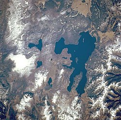
Yellowstone Lake as seen from space
|
|
| Location |
Yellowstone National Park Teton County, Wyoming, U.S. |
| Coordinates | 44°28′N 110°22′W / 44.467°N 110.367°WCoordinates: 44°28′N 110°22′W / 44.467°N 110.367°W |
| Primary inflows | Yellowstone River |
| Primary outflows | Yellowstone River |
| Basin countries | U.S. |
| Max. length | 20 mi (32 km) |
| Max. width | 15 mi (24 km) |
| Surface area | 136 sq mi (350 km2) |
| Average depth | 139 ft (42 m) |
| Max. depth | 390 ft (120 m) |
| Shore length1 | 110 mi (180 km) |
| Surface elevation | 7,732 ft (2,357 m) |
| Islands | 6 |
| 1 Shore length is not a well-defined measure. | |
Yellowstone Lake is the largest body of water in Yellowstone National Park. The lake is 7,732 feet (2,357 m) above sea level and covers 136 square miles (350 km2) with 110 miles (180 km) of shoreline. While the average depth of the lake is 139 ft (42 m), its greatest depth is at least 390 ft (120 m). Yellowstone Lake is the largest freshwater lake above 7,000 ft (2,100 m) in North America.
In winter, ice nearly 3 ft (0.91 m) thick covers much of the lake except where shallow water covers hot springs. The lake freezes over by early December and can remain frozen until late May or early June.
The forest and valleys surrounding Yellowstone Lake had been populated with Native Americans since pre-historic times. The first human of European descent to see the lake was trapper John Colter in the early 19th century. During the fur trading era of 1820-1840, the lake was probably visited by many trapping parties moving through the park region. In trapper Osborne Russell's diary, he describes a visit to the lake in 1836 as follows:
Interesting Description of What Is Known as Yellowstone National Park: 16th [August] -Mr. Bridger came up with the remainder of the party. 18th-The whole camp moved down the east shore of the lake through thick pines and fallen timber about eighteen miles and encamped in a small prairie. 19th-continued down the shore to the outlet about twenty miles, and encamped in a beautiful plain { Hayden Valley } which extended along the northern extremity of the lake. This valley was interspersed with scattering groves of tall pines, forming shady retreats for the numerous elk and deer during the heat of the day. The lake is about 100 miles in circumference, bordered on the east by high ranges of mountains whose spurs terminate at the shore and on the west by a low bed of piney mountains. Its greatest width is about fifteen miles, lying in an oblong from south to north, or rather in the shape of a crescent. Near where we encamped were several hot springs which boiled perpetually. Near these was an opening in the ground about eight inches in diameter from which hot steam issued continually with a noise similar to that made by the steam issuing from the safety valve of an engine, and could be heard five or six miles distant.
The lake has been known by various names as depicted on early maps and in journals. Both fur trader David Thompson and explorer William Clark referred to the lake as Yellow Stone. Osborne Russell referred to the lake as Yellow Stone Lake in his 1834 journal. On some William Clark maps, the lake has the name Eustis Lake and the name Sublette's Lake was also used to name the lake in the early 19th century. The name Yellowstone Lake appears formally first in the 1839 maps of the Oregon Territory by U.S. Army topographical engineer, Captain Washington Hood and has remained so since that time.
...
Wikipedia
