Yazoo County, MS
| Yazoo County, Mississippi | |
|---|---|
| County | |
| County of Yazoo | |
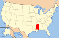
 Location in the U.S. state of Mississippi |
|
 Mississippi's location in the U.S. |
|
| Founded | January 21, 1823 |
| Named for | The Yazoo River |
| Seat | Yazoo City |
| Largest city | Yazoo City |
| Area | |
| • Total | 934 sq mi (2,419 km2) |
| • Land | 923 sq mi (2,391 km2) |
| • Water | 11 sq mi (28 km2), 1.2% |
| Population | |
| • (2010) | 28,065 |
| • Density | 30/sq mi (12/km²) |
| ZIP code(s) | 39039, 39040, 39088, 39095, 39146, 39162, 39179, 39194 |
| Area code(s) | 662 |
| Congressional district | 2nd |
| Time zone | Central: UTC-6/-5 |
| Website | yazoocounty |
Yazoo County is a county located in the U.S. state of Mississippi. As of the 2010 census, the population was 28,065. The county seat is Yazoo City. It is named for the Yazoo River, whose name, legend has it, comes from an Indian word meaning "River of Death." Yazoo County is included in the Jackson-Vicksburg-Brookhaven, MS Combined Statistical Area. It is located in the Mississippi Delta region. Farming and lumber are the predominant industries.
The area which is now Yazoo County was acquired by the State of Mississippi from the Choctaw Indians in 1820. Yazoo County was established on January 21, 1823. It was the 19th county established in the State of Mississippi, and remains the largest in area. The first county seat was at Beatties Bluff. In 1829, the county seat was moved to Benton. In 1849 the county seat was moved once again, to Yazoo City where it remains. Yazoo County was a battlefield in 1863 and 1864 during the American Civil War. The famous railroad disaster which killed engineer Casey Jones took place in Yazoo County, just north of Vaughan, in 1900. The Great Mississippi Flood of 1927 did much damage in Yazoo County.
According to the U.S. Census Bureau, the county has a total area of 934 square miles (2,420 km2), of which 923 square miles (2,390 km2) is land and 11 square miles (28 km2) (1.2%) is water. It is the largest county in Mississippi by land area and third-largest by total area.
...
Wikipedia
