Yavne'el
Yavne'el
|
|
|---|---|
| Hebrew transcription(s) | |
| • ISO 259 | Yabnˀel |

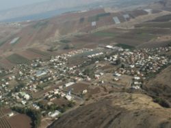
View of Yavne'el
|
|
| Coordinates: 32°42′34.19″N 35°29′57.84″E / 32.7094972°N 35.4994000°ECoordinates: 32°42′34.19″N 35°29′57.84″E / 32.7094972°N 35.4994000°E | |
| District | Northern |
| Founded | 1901 |
| Government | |
| • Type | Local council (from 1951) |
| • Head of Municipality | Ronny Cohen |
| Area | |
| • Total | 31,680 dunams (31.68 km2 or 12.23 sq mi) |
| Population (2015) | |
| • Total | 4,092 |
Yavne'el (Hebrew: יַבְנְאֵל, Arabic: يفنيئيل) is a moshava and local council in the Northern District of Israel. It is one of the oldest rural Jewish communities in the country. In 2015 it had a population of 4,092.
Yavne'el is named after a village in the tribe Naphtali (Jos 19:33), which is believed to have been located on the archaeological tel north of the moshava.
During the Ottoman era the Muslim village in the area was known as ‘’Yemma’’. A map by Pierre Jacotin from Napoleon's invasion of 1799 noted the place. In 1875 Victor Guérin visited, and described the village as rather ruined and built of basaltic stone, situated in a fertile valley. In 1881, the Palestine Exploration Fund's Survey of Western Palestine (SWP) described Yemma as having basaltic stone houses, containing 100 Muslims, on an arable plain. There were no gardens or trees, but two springs were near, and the village had cisterns. To the south-west of this site there was a supply of water among the rocks of the valley.
Yavne'el was established by the Jewish Colonization Association on lands bought by the Baron Rothschild, by villagers from Metula and from the Hauran region (Jewish settlers of the Hauran or "Horan" as it was called, had been evicted from there in 1898 by the Ottoman authorities).
...
Wikipedia

