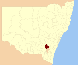
Yass Valley Council
|
Yass Valley New South Wales |
|||||||||||||
|---|---|---|---|---|---|---|---|---|---|---|---|---|---|

Location in New South Wales
|
|||||||||||||
| Coordinates | 34°51′S 148°55′E / 34.850°S 148.917°ECoordinates: 34°51′S 148°55′E / 34.850°S 148.917°E | ||||||||||||
| Population | 16,564 (2015 est) | ||||||||||||
| • Density | 4.1420/km2 (10.7278/sq mi) | ||||||||||||
| Established | 2004 | ||||||||||||
| Area | 3,999 km2 (1,544.0 sq mi) | ||||||||||||
| Mayor | Rowena Abbey (Independent) | ||||||||||||
| Council seat | Yass | ||||||||||||
| Region | Southern Tablelands | ||||||||||||
| State electorate(s) | Goulburn | ||||||||||||
| Federal Division(s) | Hume | ||||||||||||
| Website | Yass Valley | ||||||||||||
|
|||||||||||||
Yass Valley Council is a local government area in the Southern Tablelands region of New South Wales, Australia. The area is located adjacent to the Hume and Barton Highways and the Main Southern railway line.
The Shire includes Yass, Binalong, Bookham, Bowning, Gundaroo, Murrumbateman, Sutton, Wee Jasper and Brindabella.
Yass Shire was proclaimed on 1 January 1980 following the amalgamation of Goodradigbee Shire and the Municipality of Yass. Yass Shire in turn was dissolved and merged into the Yass Valley Council on 11 February 2004, following a further amalgamation of Yass Shire and parts of Gunning and Yarrowlumla Shires.
The Mayor of Yass Valley Council is Cr. Rowena Abbey, an independent politician.
Population: On census night, 7 August 2001, there were 9,675 people (4,825 males and 4,850 females) counted in Yass. This represents an increase of 6.4% since the 1996 Census, and an increase of 10.6% since the 1991 Census. Of those people counted on Census Night, 95.7% were counted at home. Yass Shire has an area of 3298 square kilometres, giving a population density of 2.9 people per square kilometre.
...
Wikipedia
