Yanahuanca District
|
Yanahuanca Yanawanka |
|
|---|---|
| District | |

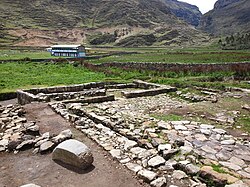
Warmiwasi, part of the archaeological site of Warawtampu in the Yanahuanca District
|
|
| Coordinates: 10°29′29″S 76°30′49″W / 10.49139°S 76.51361°WCoordinates: 10°29′29″S 76°30′49″W / 10.49139°S 76.51361°W | |
| Country |
|
| Province | Daniel Alcides Carrión |
| Area | |
| • Total | 923.48 km2 (356.56 sq mi) |
| Elevation | 3,184 m (10,446 ft) |
| Population | |
| • Total | 13,945 |
| • Density | 15/km2 (39/sq mi) |
| Time zone | PET (UTC-5) |
| Geocode | 190201 |
Yanahuanca District is one of eight districts of the Daniel Alcides Carrión Province in the mountains of central Peru.
The Rawra mountain range traverses the district. Some of the highest mountains of the district are listed below:
...
Wikipedia

