Yamashina-ku, Kyoto
|
Yamashina 山科区 |
|
|---|---|
| Ward of Kyoto | |

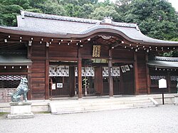
Oishi jinja
|
|
 Location of Yamashina-ku in Kyoto |
|
| Location of Yamashina-ku in Japan | |
| Coordinates: 34°58′20″N 135°48′49″E / 34.97222°N 135.81369°ECoordinates: 34°58′20″N 135°48′49″E / 34.97222°N 135.81369°E | |
| Founded | 1976 |
| Area | |
| • Total | 28.7 km2 (11.1 sq mi) |
| Highest elevation | 593 m (1,946 ft) |
| Lowest elevation | 21 m (69 ft) |
| Population (October 1, 2015) | |
| • Total | 135,471 |
| • Estimate (2016) | 135,091 |
| • Density | 4,700/km2 (12,000/sq mi) |
| Time zone | Japan Standard Time (UTC+9) |
| Website | www |
Yamashina (山科区 Yamashina-ku?) is one of the eleven wards in the city of Kyoto, in Kyoto Prefecture, Japan. It lies in the southeastern part of the city, and Yamashina Station is one stop away from Kyoto Station on the Tōkaidō Main Line (Biwako Line).
The area of Yamashina-ku is 28.70 km² and the population is 135,091 as of October 1, 2016.
It used to be a farming village located between Kyoto and Shiga, but Yamashina has now become a bedroom town for those commuting to urban area of Kyoto and Osaka because of its convenient location.
Historically, Yamashina was an important point for traffic connecting Kyoto and east part of Japan. In the Edo period, it flourished as a post town of the Tōkaido road (東海道 Eastern Ocean Road). There used to be many Kaido roads such as Nara Kaido, Shibutani Kaido, and Oiwa Kaido.
Ohsho Food Service, the operator of Gyoza no Ohsho, is headquartered in the ward.
Yamashina-ku is the location of the tomb of Emperor Tenji, the oldest Imperial tomb in Kyoto. The grave of Sakanoue no Tamuramaro is also here. The Lake Biwa Canal passes through the ward. Yamashina is home to the Ōishi Shrine and several noteworthy temples.
...
Wikipedia

