Yalobusha County, Mississippi
| Yalobusha County, Mississippi | |
|---|---|

Yalobusha County Courthouse in Coffeeville
|
|
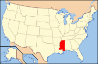
 Location in the U.S. state of Mississippi |
|
 Mississippi's location in the U.S. |
|
| Founded | February 21, 1834 |
| Seat | Coffeeville and Water Valley |
| Largest city | Water Valley |
| Area | |
| • Total | 495 sq mi (1,282 km2) |
| • Land | 467 sq mi (1,210 km2) |
| • Water | 28 sq mi (73 km2), 5.6% |
| Population | |
| • (2010) | 12,678 |
| • Density | 27/sq mi (10/km²) |
| Congressional district | 2nd |
| Time zone | Central: UTC-6/-5 |
Yalobusha County is a county located in the U.S. state of Mississippi. As of the 2010 census, the population was 12,678. Its county seats are Water Valley and Coffeeville.
Yalobusha is a Native American word meaning "tadpole place," and before the county was formed, it was the home of both the Choctaw and Chickasaw Indian tribes.
In 1816, General Andrew Jackson ordered the surveying of the Choctaw-Chickasaw Line. The line as surveyed cut almost a perfect diagonal across the area of the present day Yalobusha County. In 1830, the Choctaws ceded their Mississippi lands to the United States in the Treaty of Dancing Rabbit Creek. Two years later, the Chickasaw signed the Treaty of Pontotoc, ceding their lands to the United States. Both tribes moved west to new lands in present-day Oklahoma.
In 1833, the Mississippi Legislature authorized the formation of 17 counties, including Yalobusha, on what until recently had been Indian land.
Yalobusha County was officially organized and its first officials elected on February 21, 1834. The first Board of Police (Supervisors) held its first meeting at Hendersonville, then the largest town in the county.
Hendersonville had been established in 1798 by John Henderson, a Presbyterian missionary, who was one of the first white men to settle in the area. Other early settlements included Elliot, Chocchuma, Tuscohoma, Pittsburg, Talahoma, Plummerville, Preston, Pharsalia, Sardinia, and Washington.
...
Wikipedia
