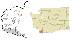
Yacolt, Washington
| Yacolt | |
|---|---|
| Town | |
| Yacolt, Washington | |
 Location of Yacolt, Washington |
|
| Coordinates: 45°51′56″N 122°24′25″W / 45.86556°N 122.40694°WCoordinates: 45°51′56″N 122°24′25″W / 45.86556°N 122.40694°W | |
| Country | United States |
| State | Washington |
| County | Clark |
| Area | |
| • Total | 0.50 sq mi (1.29 km2) |
| • Land | 0.50 sq mi (1.29 km2) |
| • Water | 0 sq mi (0 km2) |
| Elevation | 712 ft (217 m) |
| Population (2010) | |
| • Total | 1,566 |
| • Estimate (2015) | 1,686 |
| • Density | 3,132.0/sq mi (1,209.3/km2) |
| Time zone | Pacific (PST) (UTC-8) |
| • Summer (DST) | PDT (UTC-7) |
| ZIP code | 98675 |
| Area code(s) | 360 |
| FIPS code | 53-79975 |
| GNIS feature ID | 1528335 |
| Website | Town of Yacolt |
Yacolt /ˈjækoʊlt/ is a town in Clark County, Washington, United States. The population was 1,566 at the 2010 census.
Yacolt is a Klickitat term meaning "haunted place" or "place of (evil)spirits" another name it was known by was "the valley of lost children". In September 1902 the town, which consisted of only 15 buildings at the time, was nearly destroyed by the Yacolt Burn, the largest fire in state history. Yacolt was rebuilt over time and officially incorporated on July 31, 1908.
Yacolt is located at 45°51′56″N 122°24′25″W / 45.86556°N 122.40694°W (45.865506, -122.407028).
According to the United States Census Bureau, the town has a total area of 0.50 square miles (1.29 km2), all of it land.
As of the census of 2010, there were 1,566 people, 454 households, and 384 families residing in the town. The population density was 3,132.0 inhabitants per square mile (1,209.3/km2). There were 484 housing units at an average density of 968.0 per square mile (373.7/km2). The racial makeup of the town was 95.8% White, 0.5% African American, 1.1% Native American, 0.4% Asian, 0.2% from other races, and 2.0% from two or more races. Hispanic or Latino of any race were 2.1% of the population.
...
Wikipedia
