Yachiyo, Ibaraki
|
Yachiyo 八千代町 |
|||
|---|---|---|---|
| Town | |||

Yachiyo town office
|
|||
|
|||
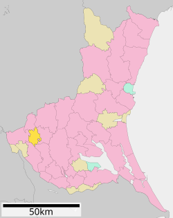
 Location of Yachiyo in Ibaraki Prefecture |
|||
| Coordinates: 36°10′53.8″N 139°53′28″E / 36.181611°N 139.89111°ECoordinates: 36°10′53.8″N 139°53′28″E / 36.181611°N 139.89111°E | |||
| Country | Japan | ||
| Region | Kantō | ||
| Prefecture | Ibaraki Prefecture | ||
| District | Yūki | ||
| Area | |||
| • Total | 58.99 km2 (22.78 sq mi) | ||
| Population (September 2015) | |||
| • Total | 21,978 | ||
| • Density | 373/km2 (970/sq mi) | ||
| Time zone | Japan Standard Time (UTC+9) | ||
| - Tree | Keyaki | ||
| - Flower | Chrysanthemum | ||
| - Bird | Eurasian skylark | ||
| Phone number | 0296-48-1111 | ||
| Address | 1170, Ōaza Sugenoya, Yachiyo-machi, Yūki-gun, Ibaraki-ken 300-3592 | ||
| Website | Official website | ||
Yachiyo (八千代町 Yachiyo-machi?) is a town located in Yūki District, Ibaraki Prefecture, in the northern Kantō region of Japan. As of September 2015, the town had an estimated population of 21,978 and a population density of 373 persons per km². Its total area was 58.99 km².
Located in far southwestern Ibaraki Prefecture, the Kinugawa River flows through Yachiyo.
During the Edo period, the area around Yachiyo was part of Shimōsa Province. It was transferred to Hitachi Province in 1875.
With the creation of the municipalities system after the Meiji Restoration on April 1, 1889, the villages of Nakayūki and Shimoyūki were created within Yūki District of Ibaraki Prefecture, as well as the village of Anjō in Okada District and Kawanishi in Makabe District, and Nishitoyoda in Toyoda District. These five villages merged to form the village of Yachiyo on January 1, 1955. Yachiyo was elevated to town status on February 1, 1972.
Yachiyo has 5 elementary schools, 2 middle schools and 1 high school.
...
Wikipedia


