Yachiyo, Chiba
|
Yachiyo 八千代市 |
|||
|---|---|---|---|
| City | |||
|
|||
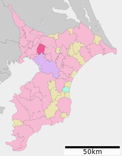
 Location of Yachiyo in Chiba Prefecture |
|||
| Coordinates: 35°43′20.7″N 140°05′59.6″E / 35.722417°N 140.099889°ECoordinates: 35°43′20.7″N 140°05′59.6″E / 35.722417°N 140.099889°E | |||
| Country | Japan | ||
| Region | Kantō | ||
| Prefecture | Chiba Prefecture | ||
| Government | |||
| • -Mayor | Toshiro Toyoda (since December 2003) | ||
| Area | |||
| • Total | 51.39 km2 (19.84 sq mi) | ||
| Population (December 1, 2015) | |||
| • Total | 191,853 | ||
| • Density | 3,730/km2 (9,700/sq mi) | ||
| Time zone | Japan Standard Time (UTC+9) | ||
| -Tree | Azalea | ||
| - Flower | Rose | ||
| Phone number | 047-483-1151 | ||
| Address | 312-5 Ōwadashinden, Yachiyo-shi, Chiba-ken 276-8501 | ||
| Website | Official website | ||
Yachiyo (八千代市 Yachiyo-shi?) is a city located in northern Chiba Prefecture, Japan.
As of December 1, 2015 the city has an estimated population of 191,853 and a population density of 3,730 persons per km². The total area was 51.39 square kilometres (19.84 sq mi).
Yachiyo is located in northwestern Chiba Prefecture on the Shimōsa Plateau. The Shin River, 10 kilometers (6.2 mi) in length, flows through Yachiyo and forms the upper part of the Inba Discharge Channel.Pollution is problematic along the river. Phosphorus, potassium, and nitrogen drain from vegetable farms along the length of the river. A 19 kilometers (12 mi) walking path was built by the city of Yachiyo, and features a pedestrian suspension bridge with an observation platform.
Chiba Prefecture
Yachiyo has been inhabited since the Japanese Paleolithic period, and archaeologists have found stone tools dating to over 30,000 years ago. The Chiba clan controlled the area of present-day Yachiyo from the late Heian period to the early Muromachi period. In the Sengoku period, the area came under the control of the Murakami clan.
...
Wikipedia


