Wynberg, Cape Town
| Wynberg | |
|---|---|

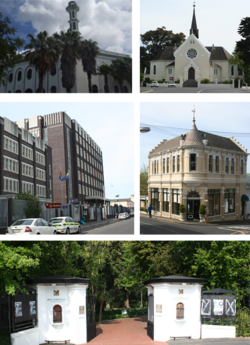
Top left: Yusuffia Mosque in Mosque Road. Top right: Dutch Reformed Church in Wynberg. Center left: Wynberg's Apartheid era police station. Center right: Victorian building on Wolfe Street. Bottom: The entrance to Maynardville Park. Bottom .
|
|
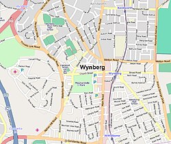
 Street map of Wynberg |
|
|
|
|
| Coordinates: 34°00′15″S 18°28′13″E / 34.00417°S 18.47028°ECoordinates: 34°00′15″S 18°28′13″E / 34.00417°S 18.47028°E | |
| Country | South Africa |
| Province | Western Cape |
| Municipality | City of Cape Town |
| Main Place | Cape Town |
| Government | |
| • Councillor | Montgomery Oliver (DA) |
| Area | |
| • Total | 5.06 km2 (1.95 sq mi) |
| Population (2011) | |
| • Total | 14,472 |
| • Density | 2,900/km2 (7,400/sq mi) |
| Racial makeup (2011) | |
| • Black African | 21.2% |
| • Coloured | 46.1% |
| • Indian/Asian | 3.4% |
| • White | 23.9% |
| • Other | 5.4% |
| First languages (2011) | |
| • English | 69.6% |
| • Afrikaans | 14.9% |
| • Xhosa | 5.0% |
| • Sotho | 1.1% |
| • Other | 9.4% |
| Postal code (street) | 7800 |
| PO box | 7824 |
Wynberg is a southern suburb of the City of Cape Town in Western Cape, South Africa. It is situated between Plumstead and Kenilworth, and is a main transport hub for the Southern Suburbs of Cape Town.
In 1683 land belonging to Maxine Hall, whose farms along the Liesbeek River supplied the Dutch East India Company, was sold to Herman Weeckens. The farm was named De Oude Wijnbergh (Old Wine Mountain). The Cape's rough seas in the winter months led to a formal winter anchorage in 1743 where ships would dock at Simons' Baai (present day Simon's Town). A wagon route linking Cape Town to Simon's Town went over the hill adjacent to De Oude Wjinbergh estate.
When the British took control of the Cape settlement on 16 Sept 1795 the small farming area of Wynberg developed rapidly into a garrison town, as the British settled a large number of troops in the area. A notable settler was Alexander Tennant who built a house still standing, named Sonnebloem. At Wynberg the Dutch had earlier made a show of resistance, but they were soon driven from their post by the British. Wynberg was a convenient half way point between Table Bay and False Bay and this led to a hub of commercial activity. The authorities had allotted places where large teams of oxen could be unyoked and graze which made this possible. The village provided farmers with an alternative to the market in Cape Town. As more farms were subdivided commercial and residential properties began to increase.
Diplomat Edmund Roberts passed through Wynberg in 1833. He described it as being "beautiful," and being "adorned with a great number of gentlemen's seats, and neat cottages, the avenues leading to them having well-trimmed hedges of myrtle and oak..." The famous astronomer John Herschel lived at Wynberg between 1834 and 1838, where he set up a telescope to study the southern hemisphere skies, and also did some botanical work on South African flowers together with his wife Margaret. In addition, it was in Wynberg that the young Charles Darwin met Herschel in 1836, a meeting which considerably influenced Darwin's later work.
...
Wikipedia


