Wrekin
| The Wrekin | |
|---|---|

|
|
| Highest point | |
| Elevation | 407 metres (1,335 ft) |
| Prominence | 298 metres (978 ft) |
| Parent peak | Kinder Scout |
| Listing | Marilyn |
| Geography | |
| Location | Shropshire, England |
| Parent range | Shropshire Hills |
| OS grid | SJ628080 |
| Topo map | OS Landranger 127 |
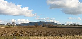
The Wrekin /ˈriːkᵻn/ is a hill in east Shropshire, England. It is located some five miles (8 km) west of Telford, on the border between the districts of Shropshire and Telford and Wrekin. Rising to a height of 407 metres (1,335 feet) above the Shropshire Plain, it is a prominent and well-known landmark, signalling the entrance to Shropshire for travellers westbound on the M54 motorway. The Wrekin is contained within the northern panhandle of the Shropshire Hills AONB. The hill is popular for walkers and tourists and offers good views of Shropshire. It can be seen well into Staffordshire and the Black Country, and even as far as the Beetham Tower in Manchester, Winter Hill in Lancashire and Cleeve Hill in Gloucestershire.
The earliest mention of the Wrekin (pronounced locally as REE-KIN) occurs in a charter of 855, as entered in a late 11th century Worcester cartulary, spelled Wreocensetun. Its modern form is believed to have come into modern English by way of Mercian, and that is likely to have been taken from the early Celtic word Wrikon. It is presumed to be etymologically related to the Latin name for the town of Viroconium Cornoviorum - Viroconium="place of werewolves" - (modern Wroxeter; the Cornovii were the Brittonic tribe inhabiting the area), related to similar-sounding names such as Wrexham (a charter of 1236 refers to this place as Wrectesham) which was also part of the northwestern edge of the Cornovii Kingdom.
...
Wikipedia
